

This article contains historical language and content that some may consider offensive, such as language used to refer to racial, ethnic and cultural groups. Please see our historical language advisory for more information.
Sometimes we researchers – including staff at Library and Archives Canada – need to navigate the archived census returns according to how the returns themselves are organized: by census sub-district. We don’t usually navigate census returns this way, since we have Census Search, our one-stop-shop database for genealogy. Once every few years, navigation by sub-district is necessary while we work to incorporate new census records into our database.
When we begin our work – and it is often tricky work – of navigating the archived census returns geographically, we often use a “step-wise” approach to narrow them down by
- province or territory;
- census district or federal electoral district; and
- census sub-district
that would have included our place of interest. We use this approach to be more efficient when searching, because there are so many census sub-districts involved: 15,167 sub-districts in the 1931 Census, to be exact.
This blog series offers five tools to help you find your place of interest among the census returns. Get ready to learn how to navigate the 1931 Census returns geographically!
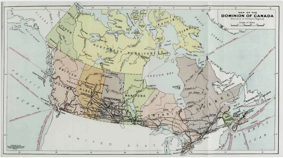
“Map of the Dominion of Canada (Exclusive of Northern Regions)” featured in the Dominion Bureau of Statistics The Canada Year Book, 1931 (OCLC 300543070)
STEP 1. Determining the province or territory
Reminders:
- The Northwest Territories had different boundaries in 1931 than it does today.
- Newfoundland and Labrador became a province of Canada in 1949, and so its population is not enumerated in the Seventh Census of Canada. (Information about the separate censuses taken of Newfoundland and Labrador in 1921, 1935 and 1945 can be found on our Newfoundland and Labrador: Census and Enumerations web page.)
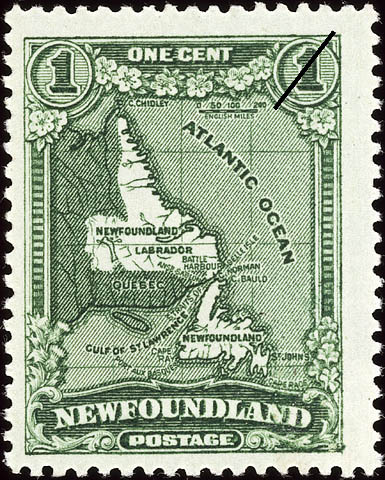
Map of Newfoundland and Labrador, July 1931, one-cent Newfoundland stamp, Perkins, Bacon & Company, © Canada Post (s001670k)
STEP 2. Determining the 1931 Census district
Lucky scenarios that let you skip Step 2
There are a few scenarios in which you may go directly to Step 3 (forthcoming in the next blog post); these scenarios include when your place of interest is
- located on a street in a major city for which Street Indexes have been prepared; or
- an “Indian Reserve” (First Nations) listed in the relevant finding aid; or
- included in the description* of sub-district boundaries.
*You can try a quick keyword search of the province-specific finding aids for sub-district descriptions: P.E.I. finding aid, N.S. finding aid, N.B. finding aid, Que. finding aid, Ont. finding aid, Man. finding aid, Sask. finding aid, Alta. finding aid and B.C. finding aid.
If your place of interest is in the territories, note that
- Yukon was census district no. 241; and
- the Northwest Territories was census district no. 242,
and go directly to Step 3 (in the next blog post).
If you cannot skip Step 2, your investigation begins with picking your preferred tool.
At Library and Archives Canada, we mainly use five online tools to help us determine in which 1931 Census district our place of interest was enumerated. The online tool that we choose is often a matter of personal preference. Some of us like lists; some of us like scrolling through old maps; some of us like navigating from the present, going backward in time; some of us prefer a quick database search; some of us know county names.
Tool 1: 1931 Census Maps research tool
This research tool lists 1931 Census districts. It also features links to maps approximating each census district. This tool is best used in a situation in which one or two census district names jump out as being likely candidates.
Note: This research tool does not include the census districts of the Northwest Territories, the District of Patricia (northern Ontario) or Unorganized (northern) Quebec.
Tool 2: Atlas of federal electoral district maps, 1924
To get a general sense of the 1931 Census district boundaries within each province, turn to the province-specific overviews in the digitized, 12-volume atlas prepared by the Department of the Interior of federal electoral district maps, 1924.
- Why federal electoral district? The boundaries of the 1931 Census districts nearly always match the boundaries of a federal electoral district as established by the Representation Act of 1924. (Stay tuned to learn why in our upcoming blog, “Why are the 1931 Census records organized geographically?”)

“Map of British Columbia showing the federal electoral districts, 1924” from an atlas of federal electoral district maps, 1924, prepared by the Department of the Interior (e011315905)
You can flip through quicker-loading thumbnail-sized images of the atlas maps; the province-specific ones are the first 11 thumbnail images of the atlas. Should you need a higher-resolution image, use the overviews: P.E.I. overview, N.S. overview, N.B. overview, Que. overview, Ont. overview, Man. overview, Sask. overview, southern Alta. overview, northern Alta. overview and B.C. overview. The digitized overview maps are hard to read in some instances, but if they are decipherable for your place of interest, they may help to identify the federal electoral district, and therefore (typically) the census district, of relevance. Should the overview map be too difficult to read, consider browsing through thumbnail images for the entire province volume in the Federal electoral district maps, 1924 atlas. You can consult the thumbnail image range for each provincial atlas in the 1931 Census Maps research tool (“digitized image item no.”). That research tool also provides links to higher-resolution images of individual maps.
Should you want a more detailed sense of the boundaries of a particular federal electoral district (and therefore, usually, census district) in a province or Yukon, consult the map for that individual federal electoral district in the digitized atlas. You can navigate to a higher-resolution image of any particular electoral district in the atlas using the 1931 Census Maps research tool.

Electoral district map for the Mont-Royal electoral district in Quebec, from an atlas of federal electoral district maps, 1924 (e011315941)
Note: If you are looking for a place in northern Ontario or Quebec, note that the District of Patricia was census district no. 244, and areas of northern Quebec were enumerated as census district no. 245.
Tool 3: Library of Parliament online list of ridings
This online resource lets you do the following:
- View a listing of federal ridings as they existed at the time of the 1931 Census. Consult the Library of Parliament’s online resource “Elections and Candidates” for the 17th Parliament, and view the constituency titles listed for the general election of July 28, 1930.
- Navigate the list of ridings represented in the House of Commons from 1867 to today. You can choose to:
-
-
- Navigate from the current federal riding, going backward in time to 1931. (Note: You can find a current federal riding using Elections Canada’s Voter Information Service database.) From the list of current federal ridings, click on a riding name. From the page for that riding, click through to previous ridings. When you get to a riding that existed in 1931, look for its description under the Information subheader “S.C. 1924, c.63” (referring to the Representation Act of 1924); or
- Search for historical ridings. On the Library of Parliament landing page for the list of ridings, in the top-right corner of the table, clear the default “currently active” filter by choosing “select all” for active and inactive ridings.
-
-
There is usually a very close match between the federal electoral riding that existed in 1931 and the 1931 Census district. You can choose to double-check the correspondence between a federal electoral riding and a census district using the 1931 Census Maps research tool.
Tool 4: Post Offices and Postmasters database
If your place of interest was likely to have had a post office in 1931, investigate what is available in our Post Offices and Postmasters database, which includes electoral districts. Try keyword searching.
Tool 5: Map of counties (and the like)
Try navigating by provincially established county (or the like). Only use this option if your place of interest is in Ontario, Quebec or an Atlantic province.
- Why counties? Ontario and eastward, provincially established counties (and the like) often, but not always, informed the shape of census districts in the early 20th century. Sometimes counties (and the like) were grouped into one census district, and sometimes counties were split into several census districts. Either way, many county names featured in census district names.

“Index map showing the counties and census divisions as organized at the census of 1931,” in the Dominion Bureau of Statistics 1937 Illiteracy and School Attendance, by Murdock C. MacLean, p. 16 (OCLC 1007622268)
First, identify the county name. To do that, consult the “key to index map” provided below or this very high-level index map of counties (if you need to zoom in). Then, pay attention to the county name (numbers are not important for our purpose). If you identify a county name, search by keyword for that county name in 1931 Census Maps research tool. If you get a unique hit in the list of 1931 Census district names, you are now ready to go to Step 3 (in the next blog post). You can always double-check if you have the right census district by using that same research tool to consult the relevant map. If the county index map is tricky to navigate for your place of interest in Ontario or eastward, don’t bother with the county index.
- Beware: The county map above does not help us to navigate the census districts used to organize the census returns from the Prairie provinces or British Columbia.
- Beware also: Census districts used to collect the census returns were sometimes different than the census divisions used to tabulate and publish the census results.
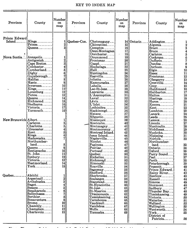
Counties, not census districts! Key to Index Map, from the Dominion Bureau of Statistics 1937 Illiteracy and School Attendance, by Murdock C. MacLean, p. 16 (OCLC 1007622268)
Don’t forget that we can help! Reach out to our genealogy team by using our Ask genealogy a question online form.
Stay tuned for Part 2 of this blog. In the meantime, we wish everyone the best in all of our searches for people and places of the past!

Were military bases enumerated differently at this time?
I was looking for a man who would have been residing in the barracks in Halifax in 1931.
Hi, our Genealogy section should be able to help you research your family history. Please use our Ask genealogy a question form: https://library-archives.canada.ca/eng/services/public/ask-us-question/pages/ask-us-question.aspx. You may also consult the following publications about the 1931 Census: Seventh census of Canada 1931, instructions to commissioners and enumerators (publications.gc.ca/pub?id=9.832323&sl=0) and Report on the seventh census of Canada, 1931 (publications.gc.ca/pub?id=9.832354&sl=0) to discover how the census and the analyses of its data were carried at the time.
Pingback: This week's crème de la crème - July 8, 2023 - Genealogy à la carteGenealogy à la carte