The Rise, Fall and Rise of the Population of the Parkes Shire Part 2 1947 – 1971
In August 2016 the latest census was conducted by the Australian Bureau of Statistics and HistoryParkes thought it would be interesting to look at how the population of the Parkes Shire has changed over the years. This is the second part on changing population figures of the area known today as the Parkes Shire (click here for The Rise, Fall and Rise of the Population of the Parkes Shire Part 1 1865 – 1953) The modern day Census – once every five years on the second Tuesday of August, was not far from being implemented by the Commonwealth Bureau of Census and Statistics (CBCS).
1947 Census
The first national census after the Second World War was conducted in 1947. It had been 12 years since the last national census, and Australia had undergone significant changes. The Great Depression, the Second World War and the commencement of the generation known as ‘the Baby Boomers’ had all had an impact on the people of the Parkes Shire.
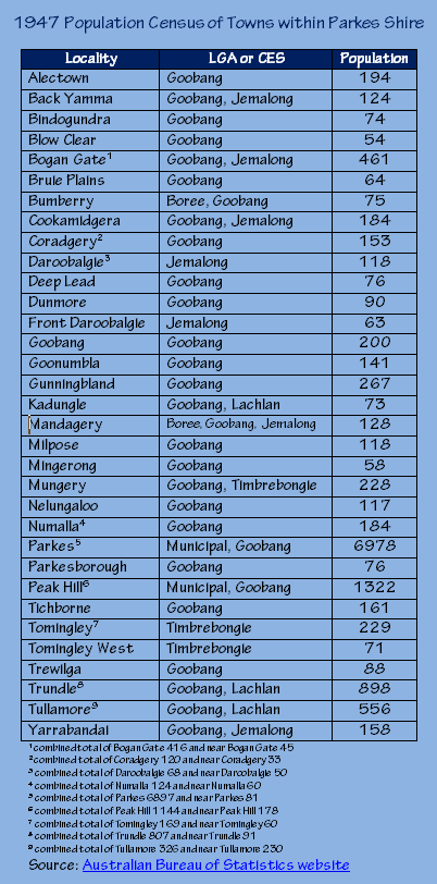
Table displaying the localities within the area now known as the Parkes Shire that were recorded in the 1947 Census, listing their results and the Local Government Area or Commonwealth Electoral Subdivision that they were part of. Source: Australian Bureau of Statistics website
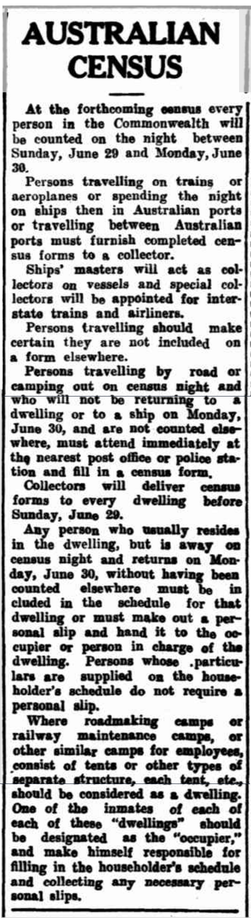
Newspaper report about the upcoming census on 30th June 1947. Instructions are included for those travelling interstate on trains and by ship. Source: Morning Bulletin (Rockhampton, Qld. : 1878 – 1954)
There were interesting impacts on the population in the Parkes Shire between the 1947 and 1954 censuses. The population rose, albeit temporarily, with the opening of the Parkes Migrant Centre at the site of the Parkes airport. This added up to 2,000 to the population at one time. In 1950 there was an increase in the amount of people affected by polio – including cases discovered at the migrant centre. Had a census been scheduled for 1950, hundreds of Forbes residents would have added to the Parkes figures. This was because severe flooding in Forbes resulted in temporary resettlement at the Parkes Migrant Centre. By 1953 the migrant centre was closed and an influenza epidemic was affecting the Central West.
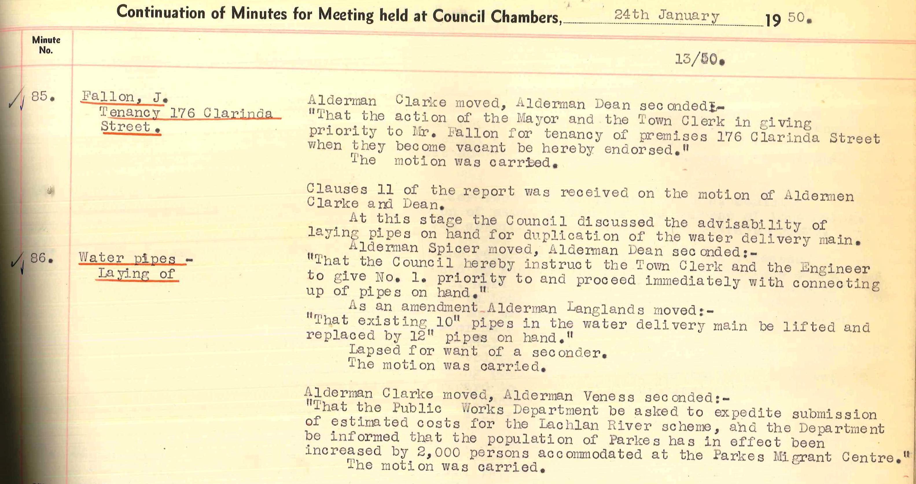
The Parkes Migrant Centre, situated on the site of Parkes Regional Airport, added to the population of the Parkes Shire. Council Minutes detail that 2,000 persons were accommodated here thus requiring additional infrastructure support. Source: Parkes Municipal Council Meeting Minutes January 24th 1950 Number 86
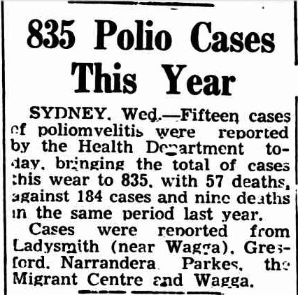
Polio – virtually unheard of today in the Central West – was on the rise in 1950, including cases discovered at Parkes Migrant Centre. Source: Daily Examiner (Grafton, NSW : 1915 – 1954)
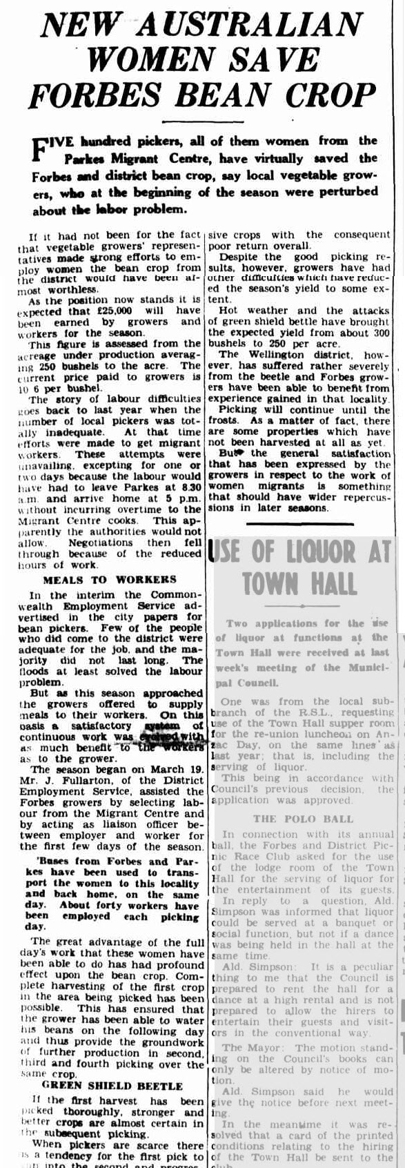
The migrant centre at Parkes saved the town of Forbes not once, but twice! This report details how the women of the Parkes Migrant Centre saved the bean crop of Forbes. Source: The Forbes Advocate
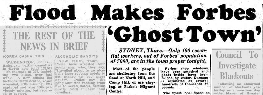
Parkes, and the facilities of its migrant centre, come to the aid of neighbouring town Forbes again. Severe flooding left Forbes being labelled a ‘ghost town’ as many flood-effected residents stayed at Parkes Migrant Centre. Source: Illawarra Daily Mercury (Wollongong, NSW : 1950 – 1954)
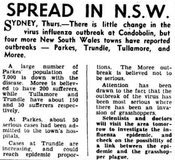
A Central West influenza outbreak brought the population of Parkes to Hobart’s newspapers. Source: The Mercury (Hobart, Tas. : 1860 – 1954)
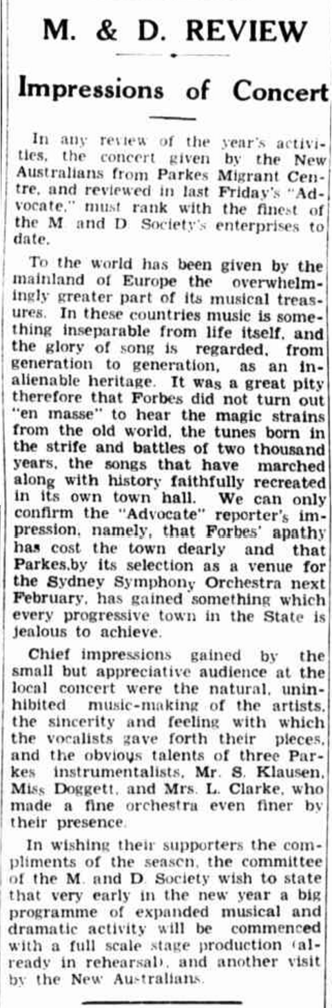
The population of Parkes increased with the intact of refugees at the Parkes Migrant Centre. The reporter demonstrates great skill to combine a musical review with a chance to fuel the rivalry between Parkes and Forbes. Source: The Forbes Advocate (NSW : 1911 – 1954)
Before the next census, the Parkes migrant camp would be empty. Its availability, along with other vacant migrant holding facilities, was a potential solution to a problem that occurs with an increase in population – homelessness.
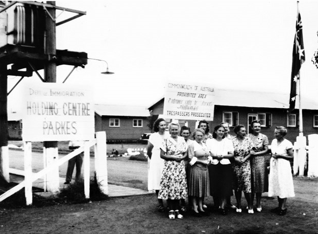
Photograph of Parkes Migrant Camp – sometimes called ‘Parkes Holding Centre’ and ‘the Migrant Hostel’ – with a group of ladies posing for the camera with Latvian weaver Anna Apinis fourth from right. Source: Anita Apinis-Herman personal website
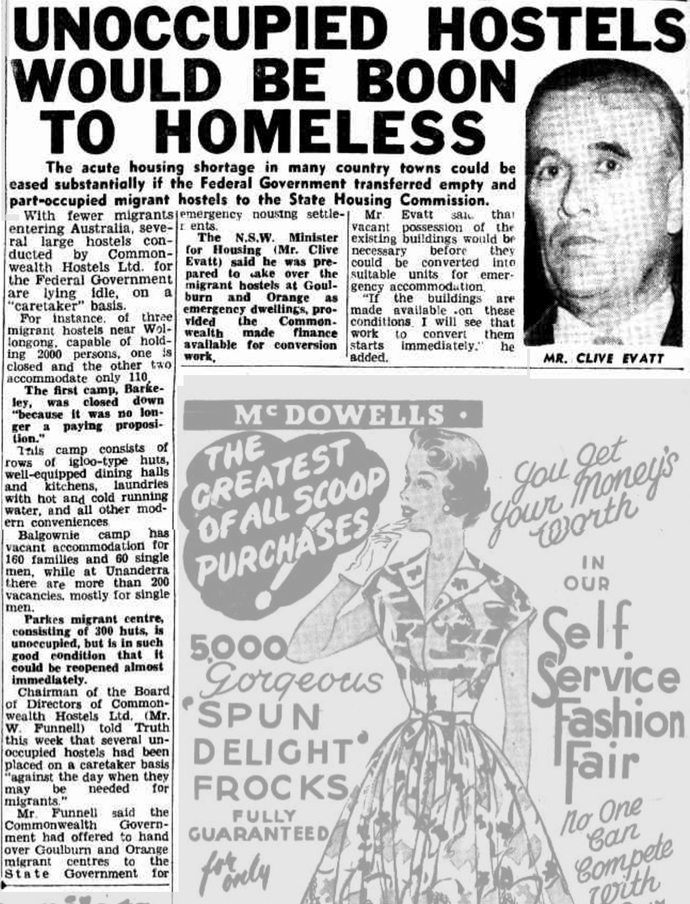
Once the home of migrants escaping the horrors of World War 2, vacant centres could become a solution to the growing homeless population. Source: Truth (Sydney, NSW : 1894 – 1954)
1954 Census
To conduct the Census, the Commonwealth Bureau of Census and Statistics divided the country into the states and territories. New South Wales was then divided into Statistical Divisions. Each Statistical Division was divided into Local Government Areas (LGAs). These were Shires except where noted as Municipalities or Census Sub-divisions. The area today known as the Parkes Shire fell into the Central Western Slope Statistical Division, with most of the region falling in the Goobang LGA, while some areas were in Jemalong, Boree, Lachlan and Timbrebongie. Parkes and Peak Hill also had some numbers counted as the municipality and some listed as Goobang Shire. Notable changes since the 1947 Census is the disappearance of Blow Clear, Bruie Plains, Coradgery, Dunmore, Front Daroobalgie, Mandagery, Milpose, Mingerong, Mungery, Numalla, and Tomingley West. New localities included Brolgan, Cooks Myalls, Harvey Park, Kadina, Kamandra, Mugincoble, and Wongalea.
The 1954 Census found the following results:
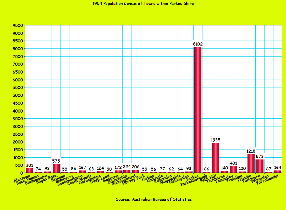
The populations figures of the various towns and villages in the are now known as the Parkes Shire. Source 1954 Census Chart made using Online Chart Tool
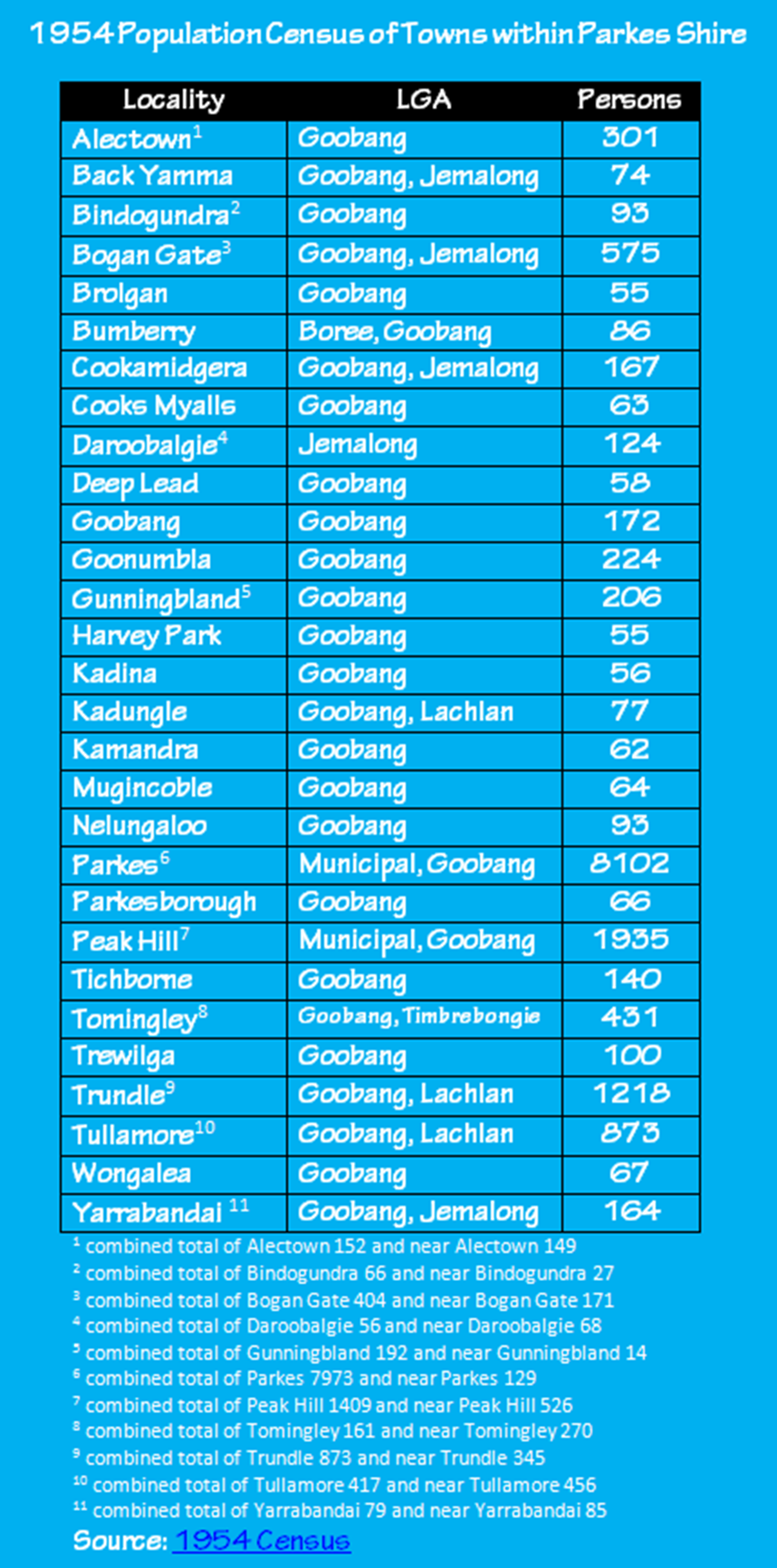
Table of the localities within the area now known as the Parkes Shire that were recorded in the 1954 Census, listing their results & Local Government Area. Source: 1954 Census
1961 Census
In 1961 the Commonwealth Bureau of Census and Statistics found the following results from its census. The census was conducted on 30th June 1961 and contained similar detail to 1954’s census. Notable differences were the disappearance of Brolgan, Deep Lead, Harvey Park, Kadina, Kamandra, Mugincoble and Wongalea. There was a new inclusion of the locality at Billabong Creek. An interesting return was that of Mandagery, which featured in the 1947 Census but not the 1954 Census and was now back listed in the 1961 Census!
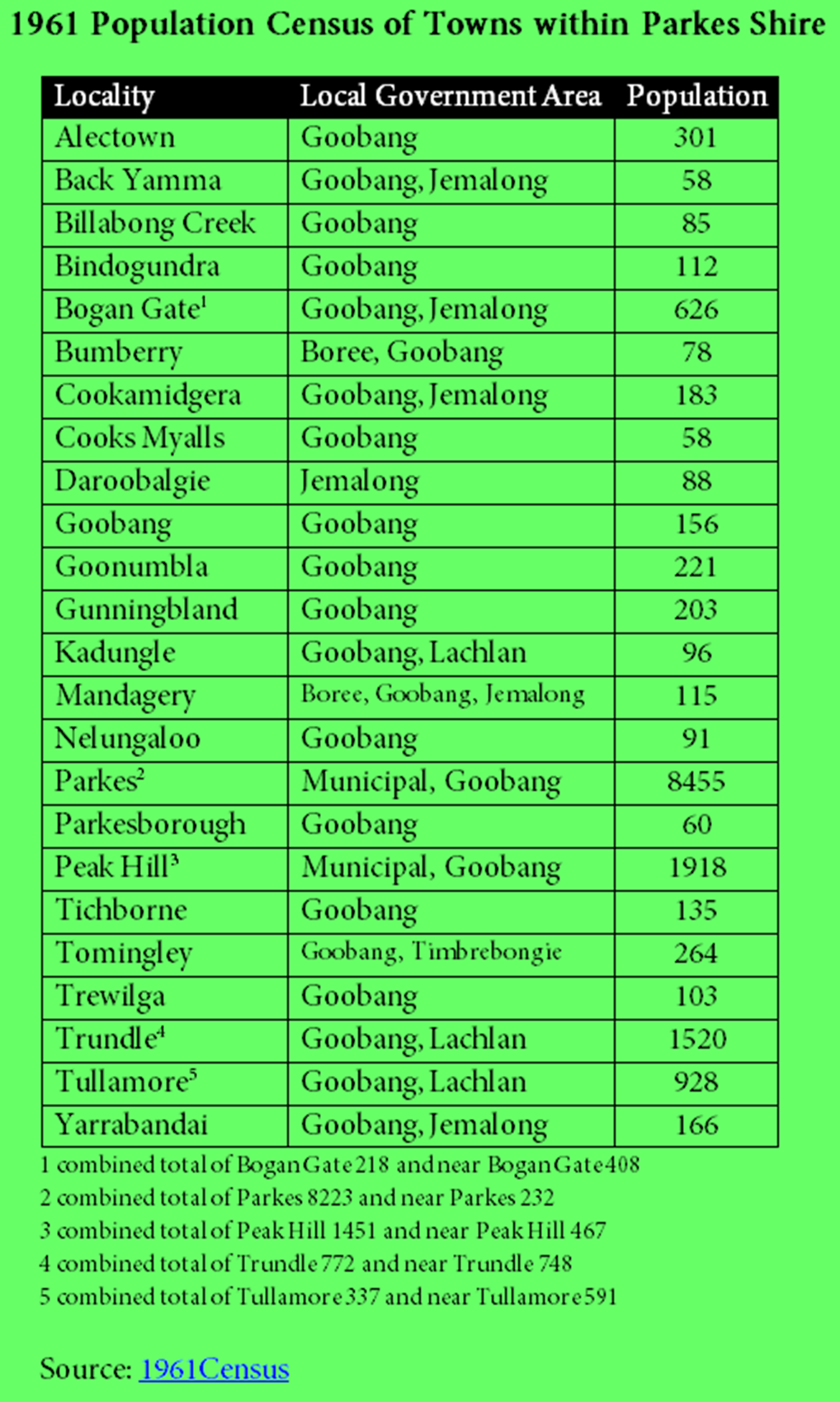
Table displaying the localities within the area now known as the Parkes Shire that were recorded in the 1961 Census, listing their results and the Local Government Area. Source: 1961 Census
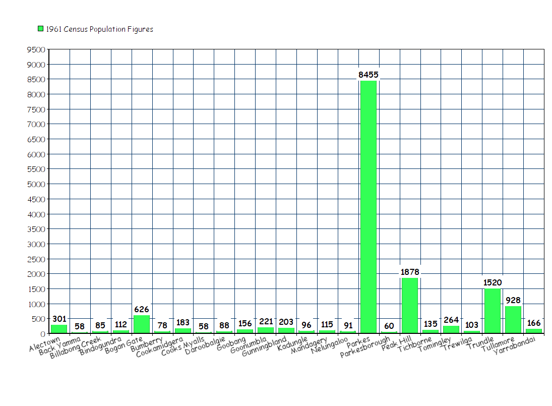
The populations figures of the various towns and villages in the Parkes Shire. Source 1961 Census Chart made using Online Chart Tool
1966 Census
In 1966 the Acting Commonwealth Statistician was J.P. O’Neill and the CBCS had devised a new way to record results. The published results related to locations which at the time of the Census had a minimum of twenty dwellings (occupied and unoccupied) and one hundred persons (in previous Censuses this was fifty persons). With the changes in population within the area, there are not as many places within the Parkes Shire listed. Under these guidelines only five places featured in the published data: Parkes, Peak Hill, Trundle, Tullamore and Bogan Gate. The figures do not include the combined total of Municipality/town and “near”. The table below only lists those within the township not the surrounding areas.
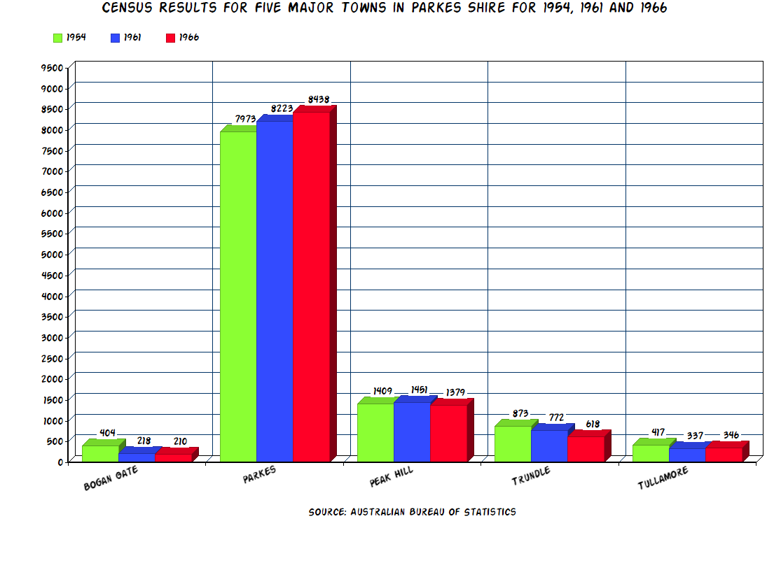
Graph highlighting the different population trends in the five largest towns within the area known today as the Parkes Shire. While Parkes Municipality is growing; Bogan Gate, Trundle and Tullamore are decreasing in population size. The Municipality of Peak Hill has remained relatively stable during this period. Source: 1954, 1961 and 1966 Censuses from Australian Bureau of Statistics website. Chart made using Online Chart Tool


Goobang Shire ~~~~~~~~~~~~~~~~~~~~~~~~~~~~~~~~~~~~~~~~~~~~~~~~~~~~~5,005 Parkes Municipality~~~~~~~~~~~~~~~~~~~~~~~~~~~~~~~~~~~~~~~~~~~~~~~~~8,438 Peak Hill Municipality ~~~~~~~~~~~~~~~~~~~~~~~~~~~~~~~~~~~~~~~~~~~~~~~1,379
Source: Australian Bureau of Statistics
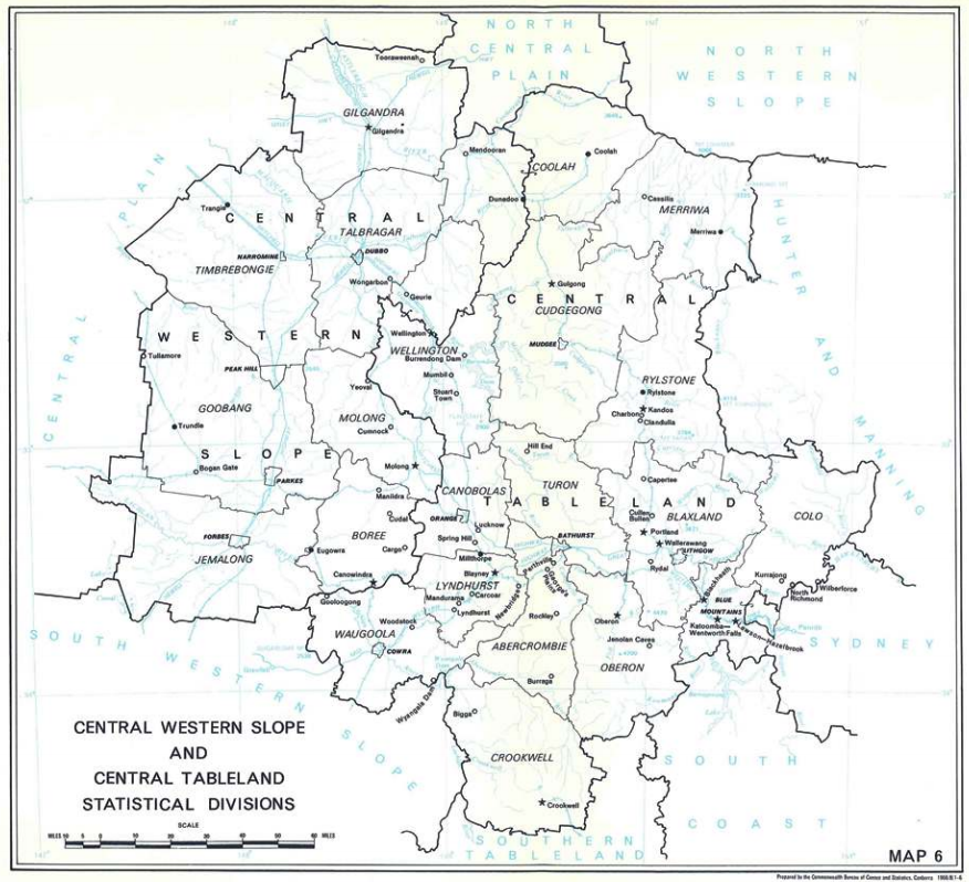
The map of Central Western Slope Statistical Division showing the LGAs of Goobang, Jemalong, Boree and Timbrebongie that data was collected from the towns in previous Census years. Only five localities featured in the 1966 Census: Parkes, Peak Hill, Bogan Gate, Trundle and Tullamore. Source: Australian Bureau of Statistics
Since the first Census – conducted by the colonies prior to Federation – Aboriginal and Torres Strait Islanders were not counted. By the late 1960s plans were in place to change this erroneous practice. Newspapers were instrumental in the change to recognise the first Australians. The Parkes Shire is within Wiradjuri nation, yet up until 1967 no Wiradjuri man, woman or child were counted in the figures for localities in the Census.
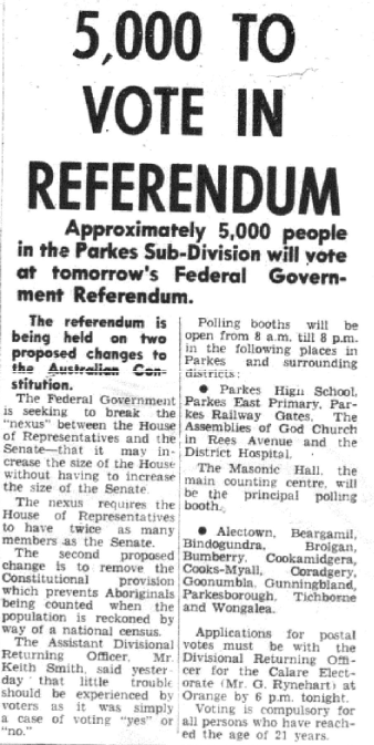
Parkes Champion Post front page story indicating how many from Parkes Sub-Division will vote on the now historic referendum. Source: Parkes Champion Post Friday May 26, 1967 page 1
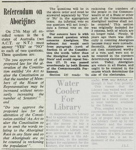
The 27th May 1967 was a day where the voting population of the Parkes Shire, along with the rest of Australia, would right one of the wrongs to the Wiradjuri people and all other indigenous nations. Source: Tharunka Tuesday 11 April 1967 page 4
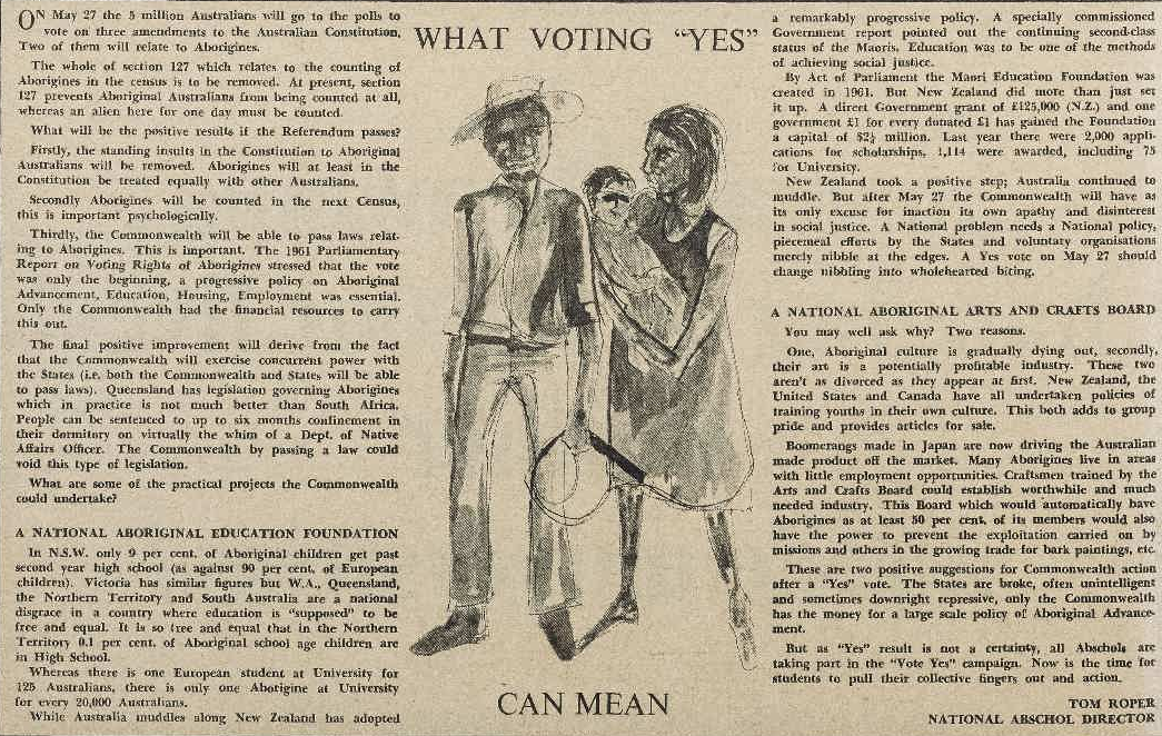
Student newspapers, such as Tharunka, helped propel the referendum issues to the forefront of the nation. Voting yes would have widespread positive consequences for indigenous Australians; including being counted in the Census. Source: Tharunka 11 May 1967 page 2
1971 Census
By 1971 the criteria for being recorded in the census was still urban centres and bounded localities with 200 or more persons. Due to changes within the community, Bogan Gate no longer qualified for its own recording. Only Parkes, Peak Hill, Trundle and Tullamore met the criteria. Parkes and Peak Hill were both recorded as Urban Centres while Trundle and Tullamore were classified as Rural. Due to the results of the 1967 referendum, Aboriginal and Torres Strait Islanders were counted in the 1971 Census for the first time.
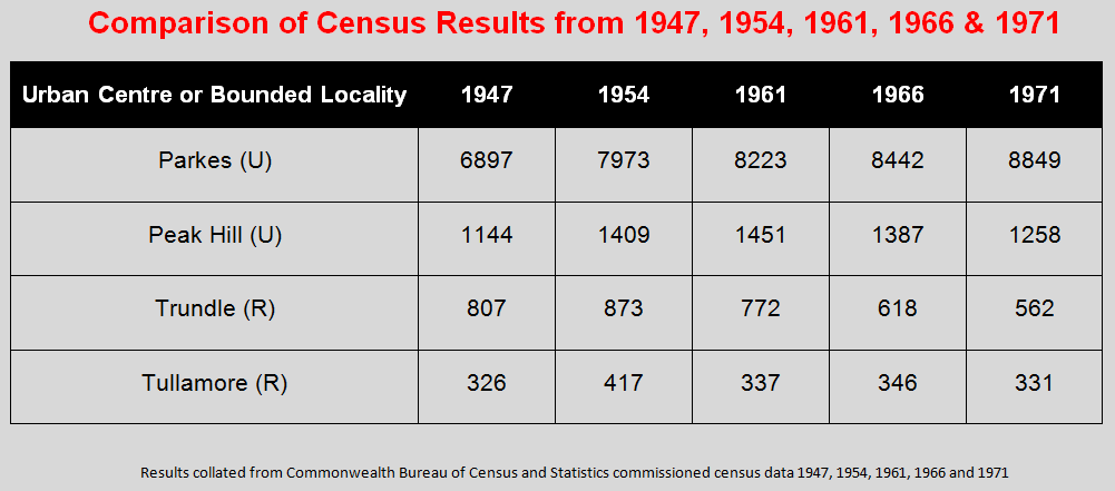
Comparison table for the four Parkes Shire towns that met criteria for inclusion in the 1971 Census. In addition there are the figures for the previous four censuses to highlight the growth of Parkes, whereas the other three centres are steadily dwindling – just like Bogan Gate which did not meet census criteria. Source: CBCS Census 1947, 1954, 1961, 1966 and 1971
TO BE CONTINUED…. Next post The Rise, Fall and Rise of the Population of the Parkes Shire Part 3 The ABS Era 1976 – Present Day
REFERENCE LIST
- Wong, L. (2012, May 17). Welcome to Wiradjuri Country [Photograph found in Snapped Signs, ABC Open, Cowra, NSW]. In ABC Open. Retrieved November 21, 2016, from https://open.abc.net.au/explore/20140 (Originally photographed 2012, May 17)
-
Wilson, R., Commonwealth Statistician. (1947). Census of the Commonwealth of Australia, 30th June 1947 (PART VIII. – POPULATION and OCCUPIED DWELLINGS in LOCALITIES) (Australia, Commonwealth Bureau of Census and Statistics). Canberra, ACT: Commonwealth Bureau of Census and Statistics. Retrieved November 25, 2016, from http://www.ausstats.abs.gov.au/ausstats/free.nsf/0/2F3A37515796B189CA25784100193B4B/$File/1947 Census – Volume I – Part VIII Population and Occupied Dwellings in Localities.pdf
- AUSTRALIAN CENSUS (1947, June 17). Morning Bulletin (Rockhampton, Qld. : 1878 – 1954), p. 7. Retrieved November 28, 2016, from http://nla.gov.au/nla.news-article56785721
- Council Meeting Minutes January 24th 1950(Rep. No. 86). (n.d.).
- 835 Polio Cases This Year (1951, April 5). Daily Examiner (Grafton, NSW : 1915 – 1954), p. 4. Retrieved November 28, 2016, from http://nla.gov.au/nla.news-article195305328
- NEW AUSTRALIAN WOMEN SAVE FORBES BEAN CROP (1951, April 17). The Forbes Advocate (NSW : 1911 – 1954), p. 1. Retrieved November 28, 2016, from http://nla.gov.au/nla.news-article219101306
- Flood Makes Forbes ‘Ghost Town’ (1952, June 20). Illawarra Daily Mercury (Wollongong, NSW : 1950 – 1954), p. 1. Retrieved November 28, 2016, from http://nla.gov.au/nla.news-article133689515
- SPREAD IN N.S.W. (1953, October 30). The Mercury (Hobart, Tas. : 1860 – 1954), p. 1. Retrieved October 12, 2016, from http://nla.gov.au/nla.news-article27175449
- M.& D. REVIEW (1949, December 23).The Forbes Advocate (NSW : 1911 – 1954), p. 12. Retrieved November 28, 2016, fromhttp://nla.gov.au/nla.news-article218700222
- Holding Centre at Parkes 1950 [Photograph]. (n.d.). New Life In Australia, http://anita850.tripod.com/, Parkes.
- UNOCCUPIED HOSTELS (1953, November 8). Truth (Sydney, NSW : 1894 – 1954), p. 64. Retrieved November 28, 2016, from http://nla.gov.au/nla.news-article168103851
- Carver, S. R., Acting Commonwealth Statistician. (1959). Census of the Commonwealth of Australia. 30th June, 1954. (Vol. 1, New South Wales) (Australia., Commonwealth Bureau of Census and Statistics.). Canberra: Commonwealth Bureau of Census and Statistics. Retrieved November 16, 2016, from http://www.ausstats.abs.gov.au/ausstats/free.nsf/0/5F8EE4B9D3A06B72CA257872001CD4DC/$File/1954 Census – Volume I – Part I NEW SOUTH WALES Analysis of Population in LGA.pdf
- Archer, K. M., Commonwealth Statistician. (1963). Census of the Commonwealth of Australia, 30th June, 1961 (Vol. 1, New South Wales) (Australia, Commonwealth Bureau of Census and Statistics). Canberra, ACT: Commonwealth Bureau of Census and Statistics. Retrieved November 16, 2016, from http://www.ausstats.abs.gov.au/ausstats/free.nsf/0/5141CD48F759E789CA2578790016B0AF/$File/1961 Census – Volume I – Part I NEW SOUTH WALES Analysis of Population in LGA.pdf
- O’Neill, J. P., Acting Commonwealth Statistician. (1967). Census of the Commonwealth of Australia, 30 June 1966 (Part 1 ed., Vol. 4, New South Wales) (Australia, Commonwealth Bureau of Census and Statistics). Canberra, Australia, ACT: Commonwealth Bureau of Census and Statistics. Retrieved November 23, 2016, from http://www.ausstats.abs.gov.au/ausstats/free.nsf/0/D311C20059D36DDFCA257880008306D7/$File/1966 Census – Volume 4 Population and Dwellings in LGA – Part 1 NSW.pdf
- O’Neill, J. P., Acting Commonwealth Statistician. (1967). Census of the Commonwealth of Australia, 30 June 1966 (Part 1 ed., Vol. 1, New South Wales) (Australia, Commonwealth Bureau of Census and Statistics). Canberra, Australia, ACT: Commonwealth Bureau of Census and Statistics. Retrieved November 23, 2016, from http://www.ausstats.abs.gov.au/ausstats/free.nsf/0/F007A27B8134D698CA2578800083C970/$File/1966 Census – Volume 5 Population and Dwellings in Localities – Part 1 NSW.pdf
- 5,000 To Vote In Referendum [Microfilm]. (1967, May 26). Parkes Champion Post, p. 1.
- Referendum on Aborigines (1967, April 11). Tharunka (Kensington, NSW : 1953 – 2010), p. 4. Retrieved November 28, 2016, from http://nla.gov.au/nla.news-article230415167
- WHAT VOTING “YES” (1967, May 11). Tharunka (Kensington, NSW : 1953 – 2010), p. 2. Retrieved November 28, 2016, from http://nla.gov.au/nla.news-article230415396
- O’Neill, J. P. (1973). Census of population and housing, 30 June 1971, Commonwealth of Australia: Bulletin 6, population and dwellings in local government areas and urban centres (Part 1 New South Wales) (Australia, Commonwealth Bureau of Census and Statistics). Canberra, ACT: Commonwealth Bureau of Census and Statistics. Retrieved November 25, 2016, from http://www.ausstats.abs.gov.au/ausstats/free.nsf/0/C62D3918BCA99584CA257884001849EA/$File/1971 Census – Bulletin No 6 – Population and Dwellings in LGA – Part 1 NSW.pdf
