
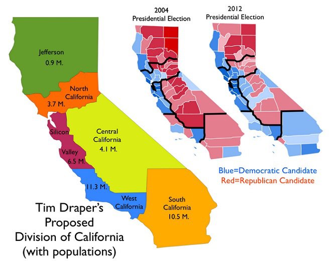
Timothy C. Draper fondly reminisced that “I grew up in the state that was number one in education, the number one place to do business and the best place to live.” The venture capitalist who brought the nation hotmail, Skype, and Tesla was savoring the new mental landscape that he argues would be recaptured by remapping California as six separate states. That simple cartographic intervention, and the “autonomy” it would serve to return each region–or all of its six new states to be carved from it–would fulfill the ideals of a rapidly receding past, and allow each to independnetly confront the problems of a crumbling infrastructure, poorly performing public schools, and pension obligations for state workers, and taxation practices that he judges unfriendly to business. The “start-up guy” sought to restart the project of California in 2014, spending $5.2 million to liberate each of the state’s six parts, which failed to make the ballot, if it gained the national spotlight thanks to Stephen Colbert. The self-defined “start-up guy” returned to the table to reparse the largest state in the union in 2018, when the notion of national division gained traction in the national news, with hopes to give a greater tax franchise to at least two of the regions–the rump “California” around Los Angeles and Orange County; “North California;” and “South California”–as if to allow citizens to self-sort themselves into their own “like-minded” communities and unique styles of governing, to reboot the largest state that had just become too populous into three.
The insistence of these aspirations to cartographic self-definition suggests, in other words, the fiction of independence that Silicon Valley has been selling the nation for some time. As Draper has argued American would be best by adopting Bitcoin as its national currency, cutting out the Federal Reserve as so much excess baggage, the big stakes questions as land maintenance, coastal commissions, and Fish & Wildlife would be deferred, as would many questions of ecological conservation and fire management that are currently on the front burners of most Californians. By persuading us to see the state as a set of discrete regions, however, bushy-eyebrowed Draper hopes to urge voters to realize his political strategy to divide California into six cantons of different hues. And when he rolled out the project for dividing the state–and its resources and economy–once again into three states, one named simply “California” on the coast below San Jose to Los Angeles, bounded by the “Northern” and “Southern” California, as if in an attempt to make the map look clearer, Draper seeks to persuade voters to overlook the complex web of natural resources (like water), but huge discrepancies in public education, pension plans, transportation needs, and water management that demand resolution in coming decades–and in effect heighten the levels of inequality already permeating the state, as well as diluting its political voice.
A six-color map of the state offered the rallying call to generate support for his map to renewed economic prosperity–a spectrum intent to underscore inherent differences between each region. The cartographic division of the state became a logo for a movement, found a nice logo in six colors, designed to strike a key in reflect the parched nature of the more arid (purple; red; orange) and waterless or irrigated areas of the state, and to suggest they were best left to fend for themselves, especially, perhaps, the orange Southern California and the Imperial Valley and bright red Central California’s desert. The coastal communities would have their liberties, and the tax franchises that went with them.
Draper’s initiative to “divide” California into six California’s–six separate states–picks up the inventive cartographies of division that partition the United States into more “rational” or “reasonable” mega-regions, macro-states, or mini-countries, and betrays what little sense he has of the environmental or ecological status of the state. His proposal stands at odds to how, back in 1837, the German-American jurist Franz Lieber famously doubted that merely altering hues of any map could affect its political economy. He doubted that “the face of our country would change” as a result, and saw little impact for changing a map’s color-scheme, and hoped that “if the engravers were able to sell their maps less boisterously painted and not as they are now, each county of each state in flaming red, bright yellow, or a flagrant orange dye arrayed, like the cover produced by the united efforts of a quilting match.” Lieber had studied topographic mapping in Dresden before coming to America, and meant to contrast realities of political economy with the coloration of maps–probably contrasting the four-color maps of the United States to those of Prussia with his Berlin-trained mind’s eye; the flagrant color-scheme of a map, however, becomes a device for Draper to urge that we remake California into six “political entities” that most of those living in them wouldn’t actually recognize.
In treating California as a landmass whose extent is able to be parceled into six–or three–blocks, the iconic visualization presumes “California” is not a landscape bound by coastal rivers, streams, glacial ice-pack, or viaducts, but might be parsed as the graphic designer wishes, in what seems the utter alienation of map from place. By converting California to six cantons, the hope is to remake the state as six more manageable mega-regions to bridge perceived distances between government and Californians. Draper represents the remapping of the state as a means to reconnect its residents to a model of good government in something of an extension of the argument of states’ rights. The graphical division of the Golden State into six entities, maxi-regions or mini-states, each emptied of local meaning and purged of cities, provides the rallying cry of the venture capitalist’s movement for the May 2016 ballot, having gained over 1.3 million signatories of in-state residents–at the time of its submission in mid-July–and of a charge that Draper hopes would open up the possibility that other states follow the lead of his movement to break into separate states as well.
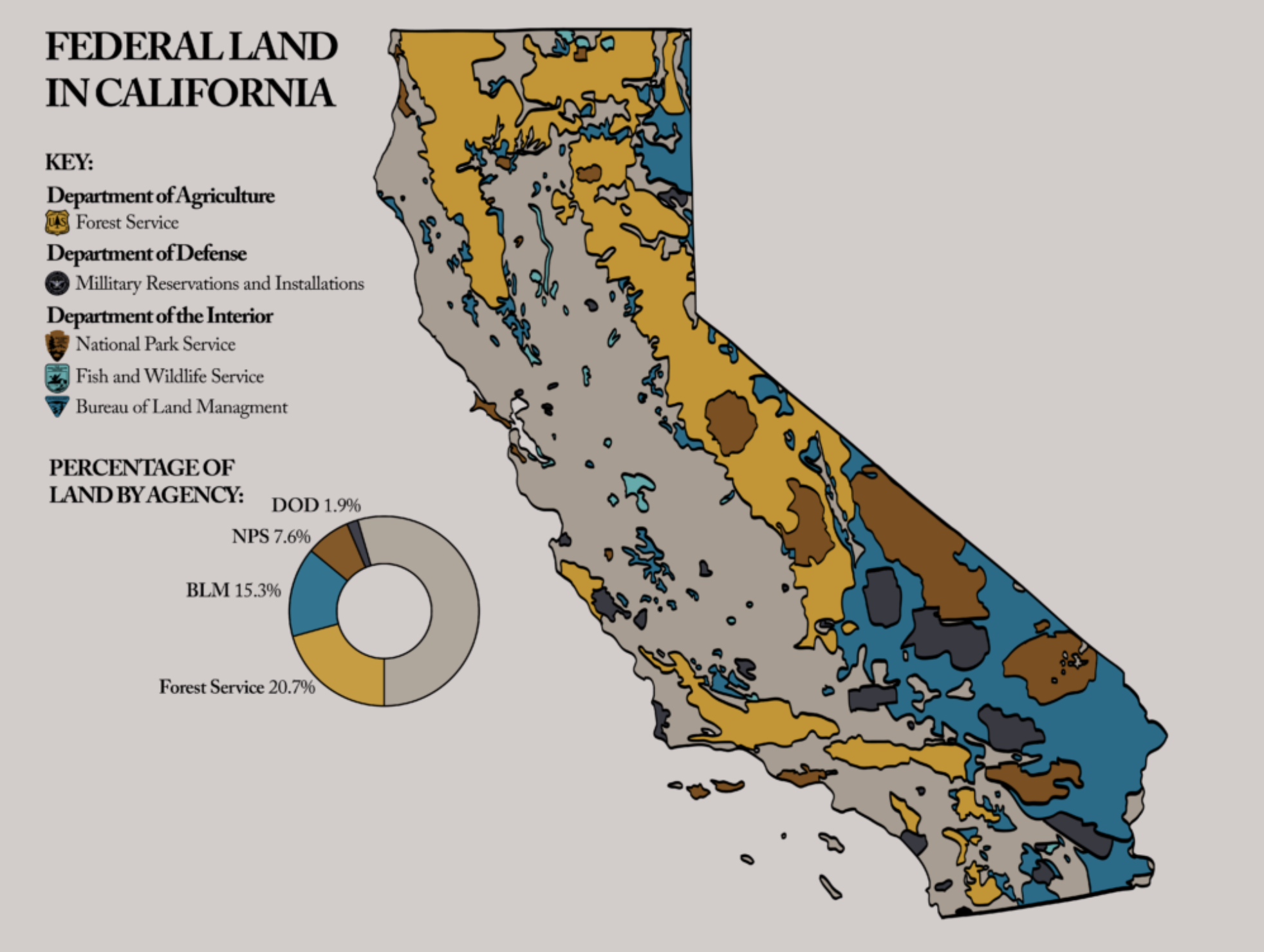
The return to the map as an iconic form of taking self-consciousness as Draper urges is a bit odd, to be sure, for a libertarian. For the image of the map as an icon of national destiny–the pentagon of France; the “lebensraum” of Germany; the unity of China–has a distinctly nationalist heritage, as does the call for a Red-State America with disturbing similarities in its contours to the Confederate States of America. The map indeed conceals, by a nice slight of hand, how much of California is “open space” managed by the U.S. Forest Service, Department of Defense, or Bureau of Land Management, in its attempt to carve up neat bundles of California in the hopes that these would align–or soon come to align–with independent interests. Fearing the administration of wilderness areas of the National Park Service or Forest Service during the Trump regime, Governor Jerry Brown had indeed not only filed a spate of twenty-four law suits against the Trump administration in 2017, the first year of the Trump Presidency, but questioned the validity of any attempt by the chief executive to sell or exchange land rights in the state, by pronouncing them void ab initio, without review by the State Land Commission, fearing the dismantling of hard-won environmental protections across the state.
Berkeley Science Review
The defense of undeveloped land that Brown holds dear and near was a pre-emptive strike that provoked a quick legal response from Jeff Sessions’ DOJ: “California was admitted to the Union upon the express condition that it would never interfere with the disposal of federal land,” he cautioned, defending the “rightful prerogatives” of the Interior Department, U.S. Military, and Bureau of Land Management “to buy, sell, exchange or donate federal properties in a lawful manner in the national interest” that should rightly make Californians fear the actual intent of the U.S. Government. While the admission of California to the United States in 1850 indeed stipulated that “the people of the said State, through their legislature or otherwise, shall never interfere with the primary disposal of the public lands within its limits,” the mandate for the state’s defense over those public lands may well be, in an era of accentuated climate change and fire danger, the rationale for rationale for administering public lands had so dramatically changed since the expropriation of public lands from indigenous tribes and mandates of public land management that the threat of their misadministration or maladministration by the rapacious Interior Dept. of the Trump era had grown pronounced–and fears of the placement of lands of the Bureau of Land Management and National Parks had been warranted, given the stunning removal of public lands protections in the first year of Trump’s administration, mostly directed to review the protections of federally owned lands from oil and gas drilling, groundwater mining, logging, and offshore drilling–all triggers for immediate protection–as well as removing responses to climate change from the administration of Park Service lands. The real fears of leasing lands for oil and gas extraction had led to the leasing of 223,200 acres of public lands to private individuals in FY 2014 alone, and the expansion of such leases would render the potential influx of cash as music to Draper’s libertarian ears.
While Draper’s initiative of the “Three Californias” was not openly framed by the tussle over land management over open spaces or wilderness areas, the fact of the federal management of 45% of California’s territory provoked fear of a slippage of protection of grazing rights, timber and forest management, and development of extractive industry that were cleverly concealed by the Three Californias, and which render California a fairly unique target of free market forces. The anger DOJ barely concealed in sniping at the “extreme state law attempting to frustrate federal policy” that Attorney General Sessions may have been born from venting about the state’s resistance to policies of border protection, and the incarceration of “illegal” migrants, with the pretense of drug enforcement, but created a unique opening for Draper’s initiative, an economic bottom-line of as limited ethical scope and compass one might associate with Don Draper, the fictional composite protagonist of “Mad Men,” but aligns closely with the brutal calculus of Tim Draper’s broad-strokes vision of governmental reform. Perhaps the true base-map, if often hidden, that lies beneath the busting up of California as a state are the network of environmental protections and protection of public lands and coasts, enforced by state regulations and commissions, that would be removed by the division of the state into cantons that would be open to the free market, pried from a vision of environmental stewardship.

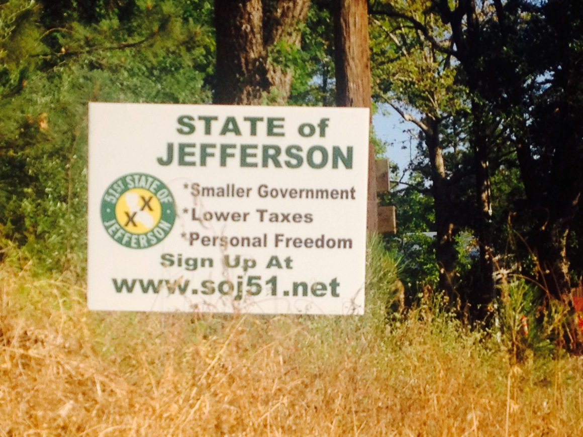
Perhaps the initiative isn’t motivated by the desire to make one state in charge of border control, or break off “West California [to] include much of what most Americans think of as stereotypical California – L.A.’s tangle of freeways, the movie industry, Disneyland and the surfing beaches up to Santa Barbara,” but to distance concerns that seem to address only part of the state from anyone living elsewhere by selective severing of what seem purely regional problems. While Draper’s own “Silicon Valley” has to an extent become its own its own region since the late 1980s, assuming its own place in the mental imaginary of the country and growing to an economy of national proportions, the independence of a region within California is more akin to rural Siskiyou County’s autonomous decision to declare its secession from the state in 2013, fed up with state regulations and a desire to protect their water rights, and to join other counties in Northern California and Oregon as “our own state,” with Humboldt County and Union District, fed up with the authority of southern California in the redistribution of water and taxes.
The notion of declaring secession as a fifty-first state to preserve one’s “way of life,” as the State of Jefferson movement, meant to evoke the spirit of the founding father, went far beyond proposals for independence in Riverside County, as declaring autonomy from the state was not only a rebellion against taxation and poor fire policies, but on securing their own water rights. The resolutions didn’t describe a political process, but capture a sense of the separate interests of the region from the state, which spread in largely rural regions to file “petitions of independence” to the legislatures of twenty-one counties, having fashioned its own flag and seal, placing a double cross against the field of a gold mining pan to symbolize feelings of abandonment of regions in California and Oregon alike to stake their claims for sovereign independence. Much as some of the support for Calexit–widely supported by anti-pluralist white separatist groups–the fragmentation of the state seems slightly in the identitarian realm of building legitimacy for white separatism, and the right of a hiving off of society based on the notion of parceling land to different cultural identities, and governments that more accurately reflect their racial or ethnic composition and values.
Calaveras County, CA (2013)
There isn’t much of actual legal basis for one-sided assertion of secession by counties, despite some historical precedent from the mid-twentieth century–but professing a libertarian ethos of not being served by the state legislature was symbolically powerful froom 2014 to 2015, and “the51s” spread like wildfire to Yuba County, Glenn County, Calaveras County, Tehama County, Sutter County, Modoc County, Lake County, and Lassen County, as signs sowed seeds for separate sovereignty as a campaign for personal freedom, in ways that were often implicitly closely tied to the retention of local water rights.
Yet even those who champion local community should be taken aback by the apparent popularity of the proposal to subdivide California as a state. Despite continued questions as to the proposition’s legality, debate about the benefit of dividing the state–and about doing so by putting the issue up to voters to decide by California’s somewhat awfully anti-democratic proposals–has provoked a small storm in an era of widespread drought. Despite Draper argument that his success of forecasting is revealed by his skillful investments in Tesla, Intel, LinkedIn, and more, his discernment of the “different issues important to different people in California” might overstate the divides into which he proposes to break the state to help its future growth. The debate is framed by proponents of the cause on their website, where Draper’s initiative, energy and funds, have animated catchy graphics that animate a cartographical fantasy that seems far more satisfactory in its color design than its translation to actual experience: the erasure of links between the states seem drawn in one region–and it’s located on the coast–as the map seems more of an expulsion and banishment than a liberation, essentially leaving four regions to fend for themselves, and treating them as if they were equal.
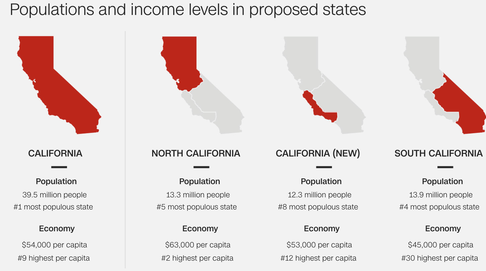
Draper’s lack of success in moving attention to the agenda–despite his snazzy logo of regional division–did not let him hesitate, in the anti-government Age of Trump, to relaunch and rebrand a strikingly similar program only several years later, in a simpler cartographic logic, and with a less catchy emblem: the “Cal3” initiative, which in 2018 stands to divide the nation into a triad of mega-local entities, has sacrificed local character and resources that Draper believes affirms support for the redesigning of the state’s tax base through “unprecedented show of support on behalf of every corner of California to create three state governments that emphasize representation, responsiveness, reliability and regional identity,” even if the notion of “regional identity” is, given the variation of proposals to split the state, not that clear.
What is at stake is the deep appeal to self-interest, however, reflected perfectly in the revised remapping of “California” as a hiving off of Silicon Valley in Cal3, a sort of rewriting of Calexit, now understood as the departure of the wealth of Silicon Valley, San Francisco, and the coast in what is trending on Twitter as “CABreakup”–at least in “#NoCABreakup,” a hashtag that essentially tries to affirm that government can do a better job of assessing and addressing the problems of the state, or at least in guaranteeing a lower tax rate for many of his friends and associates. For under the meaningless mantra of “better decision-making . . . closer to home,” the anti-government agenda of Draper was rolled out this time under the slogan “Californians deserve more”–presumably in reference to the inhabitants of the region that would be “California” in Draper’s new cartographical meta-fiction–
The opposition movement of “OneCalifornia” stands to create a worthwhile form of resistance to the deeply anti-republican ideals Draper espouses again, opening up his wallet for yet another campaign of redrawing lines of jurisdiction to profit from an anti-big government ethos in the Age of Trump, as if banking on the fact of a reduced number of voters in different areas of the state to make the appeal to self-interest work this time round, as if to profit from the southward expansion of Silicon Valley.
The deceptive roll-out of this new age of individualism and self-interest conceals the huge divide in California’s wealth and its interconnected natural resource, but rest in their imagined enlightenment of recognizing their demographic and economic equality–
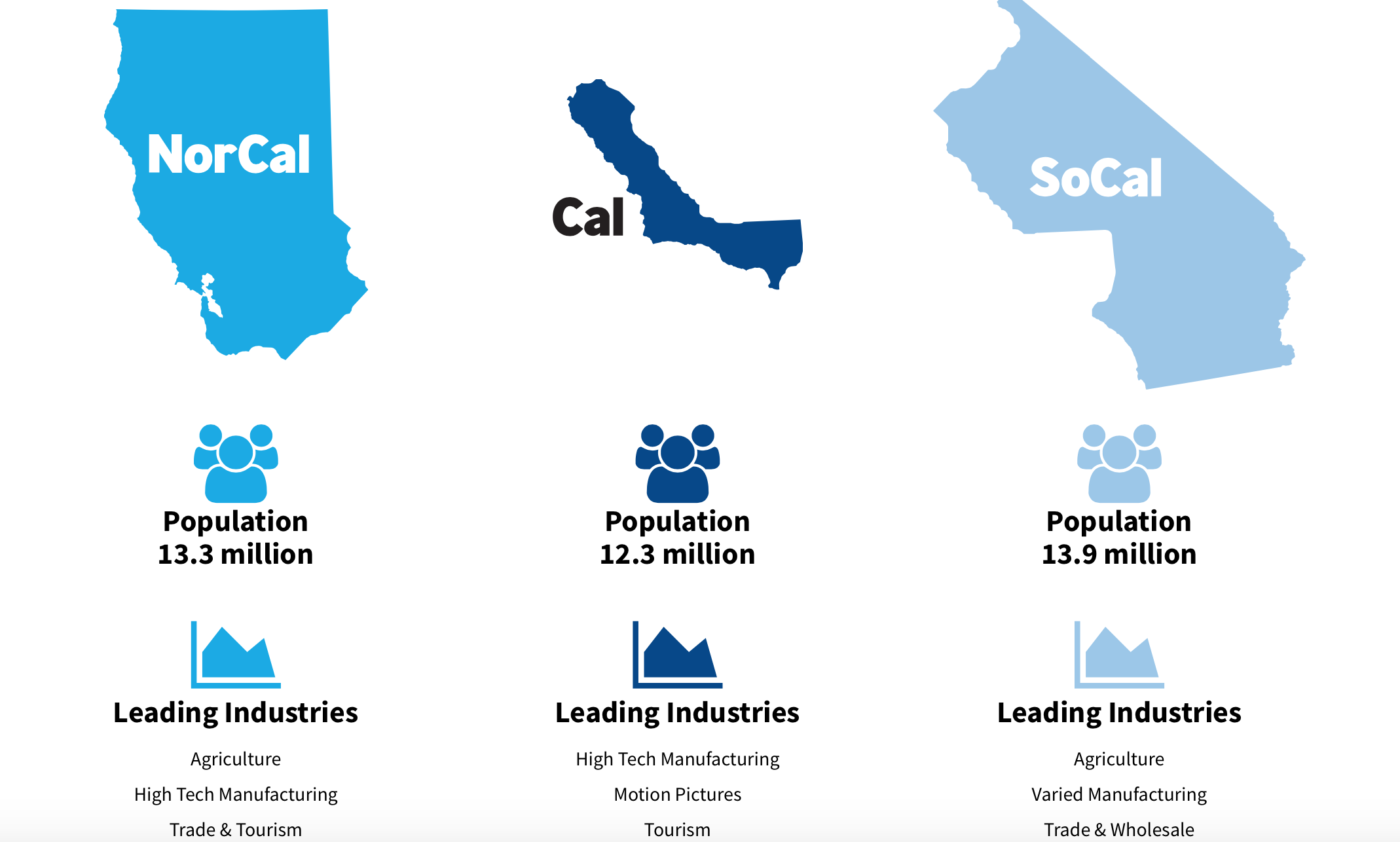
–conceals the hugely different revenues generated in each region by their population, and the different ways in which their “leading industries” are tied, rather than discrete. The Malthusian pseudo-enlightenment foregrounding of the rough equality of their respective populations seem to suggest that Draper has found a more reasonable manner of cutting up the state into allegedly equitable sections, but conceals the hugely different economic characters. Indeed, the faux appeal to reason and enlightenment even better conceals the deep interests at stake in such a division, that empties its “map” of California of local divides even more drastically, while asserting, in its new chromatic hues of varied blues, that the division wouldn’t actually be that bitter a pill to swallow at all, in deeply misleading ways.
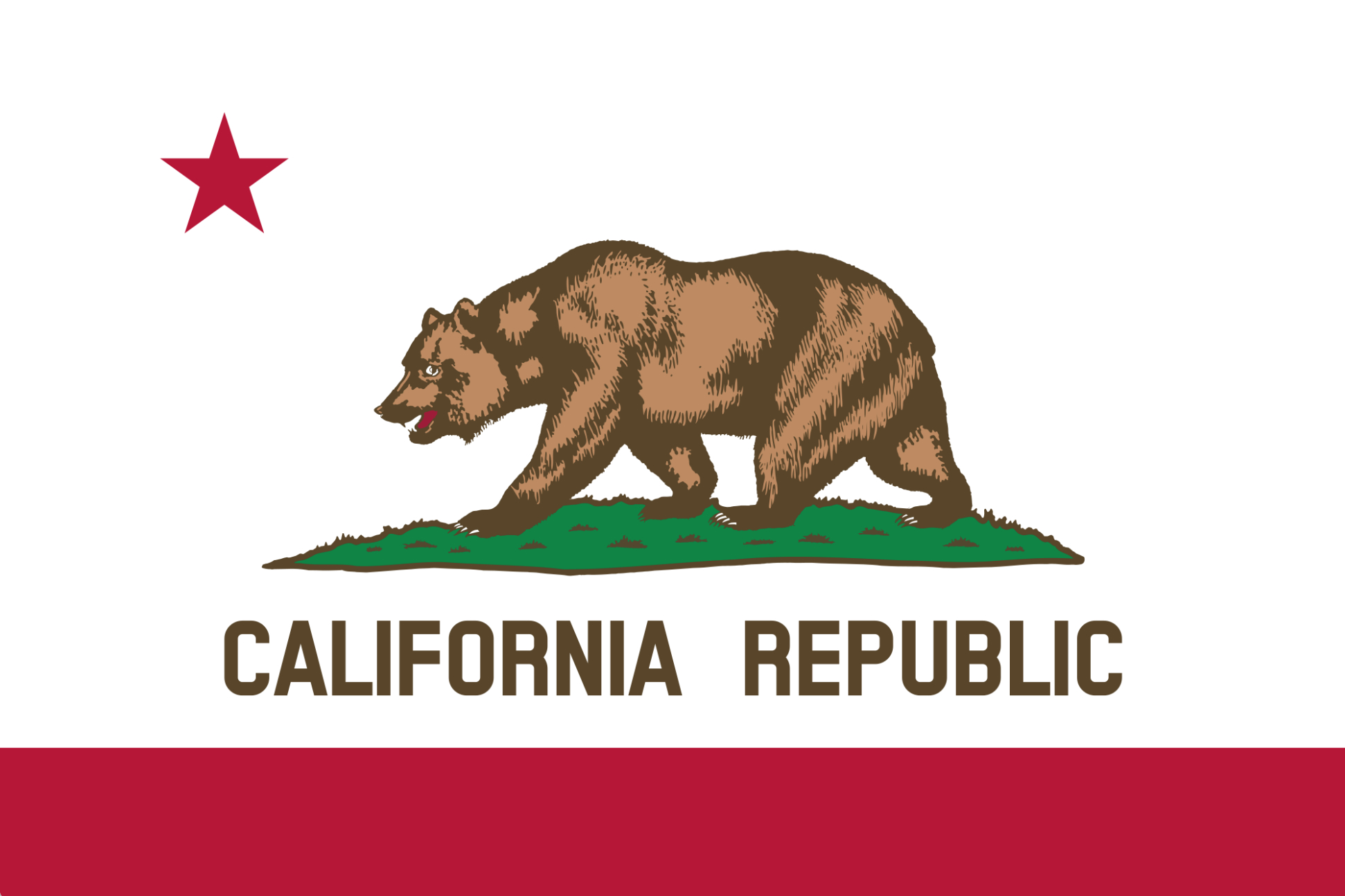
The rapidly growing population of the coastal regions suggest that the hiving off of the rump “California” boasts benefits of secession. But the bill–which, even if it fails, is a notable cartographic fiction–and the power of an imagined cartographic division, and the ridiculousness of its omission of such ties in 2018 has led to an open and entire rejection of the logic of cartographic design in the appeal to a new organic mapping of the state by the so-called “opposition” group that has mobilized against Draper’s new agenda. The effects, OneCalifornia now notes, is one of dismemberment of an organic unity, opting out of a cartographical language entirely, and referring to the state flag–an emblem of republicanism–
 –
–
–to suggest the alternative as dismemberment of a cut up bear, suggesting the divides as akin to a form of butchery, rather than following any enlightened practice of an underling logic guided by reason, and suffers the consequences of being literally drawn and quartered.

Although the poor mapping of the state into six regions was aptly foregrounded as papering over the socioeconomic units of counties and seeking to naturalize a new vision of the state’s tax base–

–the departure from a cartographical logic may indeed be a clearer way of meeting the initiative, as it resonates with the division of water rights, administration of natural resources, transportation needs, and public policy that makes California so unique. And in an age when we need better public transportation, with Silicon Valley having developed far more speedy ways to send data over the internet or bounce streaming off satellites than to move people across an actual geography–public transit across the eighteen miles from Palo Alto to San Jose taking nearly half an hour, albeit biking also offers a speedy solution–the division of California seems more of a crash and burn strategy than a solution. With real problems from pensions to state education lying on the front burner of future generations, as well as transit, the proposed parcelization of the state throws up one’s hands at the possibility of consensus, in the name of letting a free market reign, leaving “Southern California” in the lurch, with limited water, and boosting more power in Sacramento than it had before.

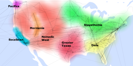
1. Revising borderlines is certainly a great way to create distance in the name of promoting greater transparency that the initiative promotes. The declarative finality of the map seems a great way to close debate, rather than advance it, by revealing and promoting fault-lines of which Californians weren’t even aware. The finality of the map that is the logo of the proposal that Draper hopes to put before voters in 2016 is, tellingly, both bleached of toponymy and of local knowledge of the regions that it separates by whitespace borders. In indicating six districts or proto-states in which he imagined the monolith “California” might be good to divide and cantonize, the image is conveniently oblivious of what the “new borders,” for all their alleged objectivity, might in practice mean–assimilating hinterlands to major cities would surely diminish consensus and accentuate new divides; he argues the divisions reflect the “very different personalities” and economic and political priorities of the residents of each of these regions.
Indeed, the habitual carving of countries by data visualizations lends increased credibility to new parsing of provocative lines of political divisions that effectively work disrupt their symbolic unity, presenting an argument that the size of these six state offer a template to restore the good days of local government, as if that would somehow leave California both more responsive and responsible to state-wide problems. For the proposal seeks to redress the distance at which each region’s interests have come to lie from Sacramento, and to appeal to the self-interest of voters. For Draper’s movement, the division would respond to the balancing of the different interests of each region, although only those of Silicon Valley seem defined: Draper has discussed, for example, how a “large group in Sacramento” grew so “very isolated” from the “very different personalities” of each region to find it impossible to prioritize such concerns as Silicon Valley’s prioritizing H-1B_visas, or Southern Californians’ concern with immigration, as if their distance in Sacramento exacerbated the problem of “trying to balance the interests of people all up and down this coast” more than partisan gridlock.
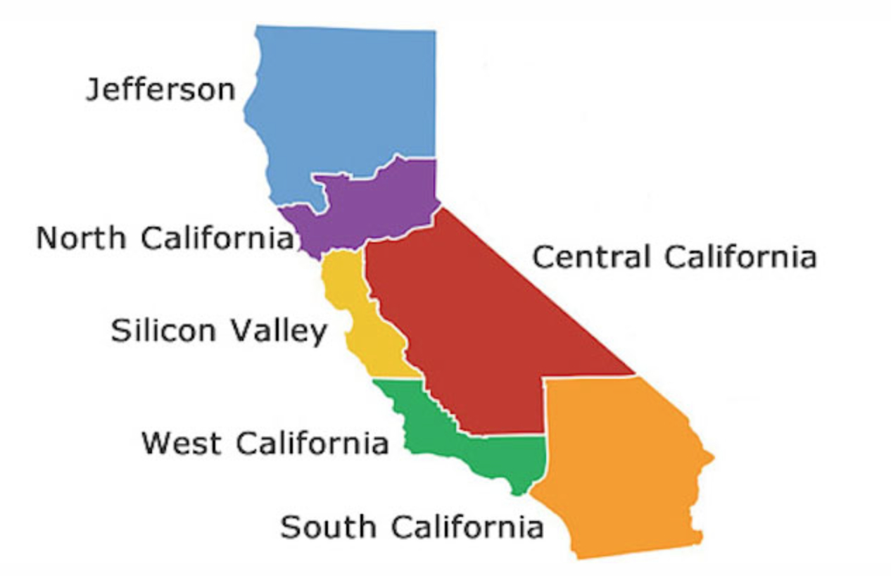
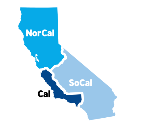
The proposed remapping of California’s coast–a landmark achievement of environmental management–indeed seems central to the canonization his group advocates: five coastal regions seem the template for the division of the state; names of most coastal regions include “California” as if to remind residents that they only seek to preserve the best interests of the state: “North California,” “Central California,” and “West California,” remind residents they have the state’s best interest at stake, notwithstanding the peripheral “Jefferson” and the massive new regional”Silicon Valley,” which is expanded to include choice properties around San Francisco, as if spatially linked by the web of private commute buses not only to the Bay Area but also much further north to Mendocino. (Perhaps this is one of the true agendas of the movement for Six Californias: not to break up California into regions like “South California” and “Jefferson,” but to make “California” a setting in which Silicon Valley, the place where Draper lives and works, can expand to attain the sort of place on the map that it deserves.)
The proposal to partition the Golden Sate echoes past proposals of splitting off, hiving, or partitioning of many of the lower forty eight. Andrew Shears of Mansfield University has taken the time to collate and synthesize many of these movements in a stunning exercise of an “alternate history”of what might have been, using a list of U.S. State Partition Proposals, that multiplies the familiar fifty states in the union to a whopping 124 proposed states–with a disclaimer about advocating such multiple proposals.

The similarities between the “Draperized” map of California and collapsed movements of secession that Shears mapped in the state are curious. They probably partly reflect the massive settlement of the California coast and its concentration of capital–the proposal carves “Silicon Valley” out of California’s coastline and adds both West California and North California to it. Unlike previous calls for downsizing California that predate the announced secession of “Jefferson” in 1941, before the entry of the US into World War II, the argument is to create more responsible government, rather than that distinguishing the region of “Coastal California” would allow an ample conservative voice for denizens of the interior of the state. The map that demonstrated the splitting of the state has, moreover, itself become a sort of rallying cry: rather than a grass-roots phenomenon of secession from below, the disbanding of California creates a collage of cantons in which all residents will better recognize themselves.
The divisions mapped above are meant to promise “more direct contact” of the citizens with a government “now ruled by detached and isolated politicians in Sacrament,” which Draper and friends suggest splitting to six legislatures (five more), electing five more governors, and passing six separate budgets, all out of the belief that small, rather than big, is beautiful, and that local problems will be more easily resolved locally, rather than gridlock. Of course, the habitual carving of countries by data visualizations lends increased credibility to how redrawing six states would provide a better reflection of its political divisions, as if intentionally confusing such electoral divides with the state’s actual topographic landscape. For the notion of divvying up states into red and blue does create a difficulty for California, if one’s been trying to parse the ostensible national divide in the electorate that we’ve seen on news screens from at least 2000, and that now substitute for political debate–in order to create a set of state-like sectors that would reflect voter preferences that would vote reliable, we could benefit from Draper & Co.’s design, which would individuate some new “red states” in California in the electoral mosaic.
But the initiative is not only seeking to parse blue from red. For the map conceals the deep variations of income, taxation rates, and –all of which drive the red/blue schism of partisan divides in a blue state whose blues located dominantly on its coast.
2. While data visualizations are great for challenging disrupting inherited symbolic forms too often burned onto the back of our retinas, does Draper’s six-color proposal really open new space for debate? While abandoning a five-color scheme to display data, the odd choices of hues used in the “Six Californias” logo makes one wonder what is trying to be conveyed–aside from the heat of the Sierras and sandiness of the desert–save the fundamental fact that these districts should be disjoined. Sick of charges of gerrymandering, the notion is perhaps to take both the revenues produced by Silicon Valley for its local education budget and SoCal tax franchise and keep it for oneself, and leave the Central Valley a distant poor cousin where per capita income would fall below that of the state of Mississippi; now that the reduction of property taxes have dispensed with one of the best ways of reallocating capital in California, just let the tax franchise be divided to create a spectacularly wealthy shore and poorer satellite states with minimal populations, and really big water problems, posed only to accelerate with the growing drought.
What goes on with the aqueducts, rivers, canals and reservoirs is a crucially omitted point to which the end of this post will return. Putting aside problems posed for the University of California system, jewel institution of the states not to mention the wide network of community colleges, the budgeting for a far-flung elementary public school system would be immense–if the Regents would have to reconsider the whole question of in-state tuition, as well as the viability of the system. (Forget about questions of what in-state tuition would mean; would we have not only ten new senators, but six Regents?) As one who made much money on LinkedIn, does Draper envisage online education replacing the state universities? Although Draper has insisted that the division of the state into a region with twelve senators and six governors would cut a bloated bureaucracy, what, one might ask, about the work of the California Coastal Commission at a time of increased concern with rising ocean-levels and tsunami?
Or does the imagined legal elevation of the region of Silicon Valley to statehood–the apparent essence of Draper’s imaginary future division of the map, only seek to remove Sacramento’s oversight of its economy? Since the basic motive behind the division seems to be to allow the newly forged state “Silicon Valley” to hire cheaper labor from Asia without restriction, it’s probable that he wouldn’t be so interested in cultivating in-state employees, anyways. The new entity of “South California” (the amalgamated Orange and San Diego Counties, but leaving out most of Los Angeles to create a more homologous demographic) might even work to tip the balance of political representation in the US Senate, with “Central California” (the San Joaquin Valley)–assuming each of these regions would, by constitutional amendment, have two senators. The ‘proposal’ exemplifies a pretty perverse cartographical wish-fulfillment that seems more distant from reality the more closely it’s considered, or the more closely one consideres the ways that California works. Although the website addresses issues such as pension-retention and the future of in-state tuition, it barely conceals its deep self-interest and suggesting few questions of collective resolution–and little (if any) sense of awareness of the state’s geographic location or the increasing precariousness of its environment. Is proponents seem to distill all problems of governance to questions of geographic proximity, and prefer to see all resolutions as springing from the fragmenting of the state’s map into six separate sectors.
To be sure, the above parsing of the state reflects the rhetorical reconstruction of the nation into mega-regions or sub-divisions that have become increasingly popular, and play out a deep anxiety that the map has changed in ways that representational government no longer reflects, or no longer does well. Our political map needs to be redrawn, the argument goes, to better account for how the ground has changed beneath our feet. Such newly popular maps, perhaps hastened by the eye-grabbing nature of digital web-design and computer-assisted reporting, greatly profit from the ability to convert digitized cartography into a compelling meme, take their spin and part their power from the recent division of the country’s political preferences into “red” and “blue” states in news media–no matter how mutable such divisions might be, and how the division of California into two settled poles might provide a balance–as much as an argument for separatism per se. In Draper’s initiative, indeed, it has been remarkable how much the image of re-drawing the state has become the story, as if the map, rather than illustrating the situation on the ground, can become the basis for future debate and, even, the infographic the issue itself, now liberated from a purely illustrative function. It even invites the question if whether the sorts of divisions that infographics have accustomed us to see reveal actual obstacles to civic consensus or debate.
Indeed, the recent re-divisions of our chorographical maps into sharply distinguished choropleths that better distinguish divides in the nation and explicate the imagined oppositions between who’s red and who’s blue in the national news seems to have generated a range of unique solutions to better parse the nation into who watches the World Cup with attention and who doesn’t. The map provides the basis for a more eye-grabbing news story, as well as being satisfyingly direct and bare bones–spare me the time to read the paragraphs–model to consume information. Such divisions of the country into allegedly “more accurate” cartographical parings have come to seem omnipresent signifiers that circulate in the blogosphere, removed from a storyline or caption; in elevating “place” as an object of true meaning, these divisions of demography create ghosts in the machine of the nation: it’s not so surprising we’ve created alternative demographic divides and performed futurologies of the fragmentation to be brought by impending demographic shifts, or past signs of inevitable unbridgeable differences across regions that have not yet been sufficiently recognized in other maps.
The idea of the initiative is to bring the map into better correspondence with reality, so that the map better reflect the lost idea of an efficient and productive state. So why not use the five-color scheme that divides the nation to divide the nation in different ways? Creating a new national architecture for understanding our identity is not only a form of mise-en-abyme of the current rage for dividing the nation into more sensible units than that followed by the electoral college, and projecting the new sorts of urban constellations of paved earth–and the sectors of commuting they allow–that divide the nation in ways that lead one to conclude–perhaps given the recent debacles in Presidential primaries–that the state as an enitity is a thing whose time has passed, given the regional networks by which habitation, work, and priorities might be better expressed.

Draper might indeed be seeking to create a similar exercise of cartographical futurology, by improbably linking San Francisco to Silicon Valley, and merging San Diego with Orange County, and then parsing the rest of the current state to most appropriately divide whatever is left over.
Some have argued that such a division already exists–and might be historically back-projected to the country’s origins, perhaps in order to rectify the errors of the founding fathers who fathomed the federation in the first place, noting that several nations in fact exist, based on the research of the reporter Colin Woodward into the eleven nations that now make up our nation:
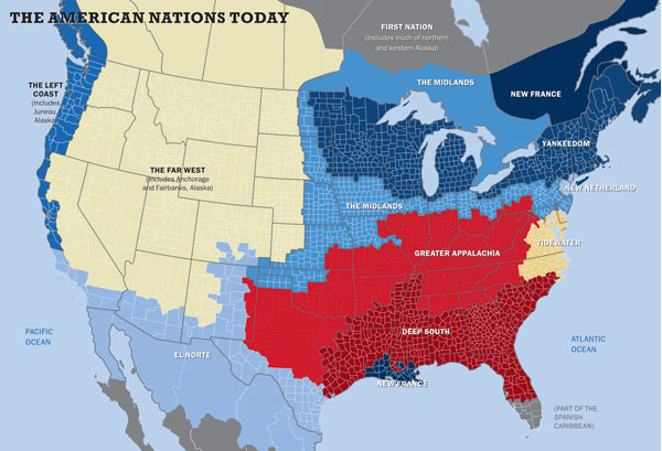
The currency of this notion that we’d do better to just divide the nation into regions seems particularly appealing as an exit-strategy to the toxic arguments of those who continue to advocate the confused concept of “states’ rights” to advocate NIMBY policy or to resist recommendations that society might be profitably adjusted to profit those disenfranchised. If we partition “Greater Appalachia,” the thought might also run, we get rid of a lot of other problems to affirming the unified policies of “Yankeedom.” (Of course, it goes unspoken that the notion that such a division of a country into mini-nations seems a way to sanction a set of “just wars” about political differences, which wouldn’t have to be “civil” but just just.) Once drawn on a chart, and hopefully in straight or straight-ish lines, the divisions of regions seem to make sense–especially if they can all be given logos that approximate new flags or a board game.

This is by no means the only means recently advocated or devised to divide the country. Creative parsing of the country into regions that the demographic of Facebook users seems to map into clusters of “Friendship” might be an alternative division of constituencies, if you posit the idea that regions should possess some inherent coherence or identity, measured that they be more likely to be Facebook “friends”–as if that could create consensus, or that it takes too much time to arrive at consensus by political debate, which in themselves map interestingly onto Woodward’s creative divides.
The data-visualizers like might also opt to divide the regions of the US into its greatest centers of population, as in this gridded cartogram that exaggerates geomorphology as weighted to number of inhabitants, in ways that reveal the increased political problem posed by the concentration of the population outside of rural regions: the population-weighted gridded gridded cartogram of the sort that is warped by the energetic cartographer Benjamin D. Hennig posits the question of how to best distribute the political process across the country that might merit a rethinking of the role of the electoral college, to be sure, and to the notion of “super”-senators to augment the voice of specific states.
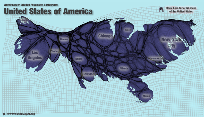
Let’s pause to reflect on the specific gridded distribution of population across the state the proposal would divide to six, and ask where its major centers would be–and reflect on how the distribution of population might inspire libertarian ideas of separatism within the state:

But how to parse populations into greater divisions doesn’t seem to be the most evident answer to problems of arriving at consensus, if that notion of national uniformity is what one really wants.
ESRI opted to map the country into ‘eco-regions,’ which might, as much as anything else, prove a manner of dividing the land, if it weren’t already inhabited-and if the divisions didn’t prove so irregular. The divisions provide no basis for a political geography. The result would be closer to the land’s geography, than the divisions the libertarian Draper put on the table–but few at ESRI would surge that these eco-regions provide aactual or effective lines of governance or of constituted economically viable units, and nor would Jefferson have endorse the solution even when we remained an agricultural state.

3. But something like this seems to be going on in Draper’s somewhat immodestly self-promoted proposal to divide California voiced as a libertarian solution to the ostensibly increasing distance of current state government in Sacramento from the people’s will. The notion that this “aims to address a variety of issues the state faces today” begins from the not so imaginative invitation “ever really think about how big California is?” that passes as a form of cartographical reflection, asking how can only one governor even be expected to look after all of its inhabitants, and resolving problems of representing Californians by the illusory simplicity of a DIY cartographical exercise that anyone should be free to weigh in upon: “you can create your state from the ground up . . . [and] have a say in what your state becomes.” The graphic indeed seems to drive the argument for how “Six Californias” can bridge the divides that have grown with governments that have so receded from local issues to become “further distant” from the very folks they represents them–“six smaller states with more local and more responsive government,”as the website has it. To shift the business plan of the government, as it were, and its “parts” are spun off to spend tax dollars more effectively and responsibly–and, despite the stacked deck of the considerably large economy in California, to compete among one another, rather than be overseen by Sacramento.
Such “draw it yourself” form of libertarian cartography is particularly deceptive as a way to resolve the state’s deep problems–and seem not only create multiple problems for the state’s existing infrastructure and educational systems with the illusion that one has done something to solve them, and argues that more problems are solved by the disaggregation of the state as a powerful means to dismantle governmental control.
The logic underlying the project of dividing the state seems be to allow each “region” to express its own interest in the most transparent ways.
Draper’s idea that remapping six California’s would be a basis to “recreate your state” that may be on the 2016 ballot has been fittingly lampooned by the cartoonist David Horsey of the LA Times. For Horsey, a revisionary map of the proto-states with their own diffident mottoes, each no doubt phrased with a suitably separatist inflection, was the unbridling of self-interest and corporate redefinition and branding that start-ups brought to all Americans as a substitute for free choice. Horsey played much more creatively with the proposed regions’ toponymy to point up the quite interested (and urban) perspectives that animate the venture capitalist’s dismemberment of the state–taking the “more effective” map of “Six Californias,” but renaming “Jefferson” as “Weed,” for example, and using the “iState” as a designation of Silicon Valley, whose motto might now become “I’ll Google It” while “Border” has selected the simple declarative “Send ‘Em Back!” (The mottoes reflect something of the self-interested nature of the initiative Draper sponsored in exempting Silicon Valley from the regulations of work-visas, to allow Silicon Valley industries and execs to hire the technological whizzes they want, without inconvenient legal obstructions.)
For Draper has proposed that a belt from Marin to Tahoe as “North California,” as if to endow it with homogeneity, and greater San Diego becomes “South California.” Horsey’s remapping of the state into regions nicely reveals just how much the continuity of such regions derives from one’s perspective. If Draper’s promise is to put voters back in touch with their representatives and destinies, the funny map into which he wants to carve the region removes the relation of the state to its major sites of agrarian production, but also to the snow packs and aquifers that until recent memory sustained much of the state, streaming down from the Sierra, or the quandary of whether the dismembered state would be able to better deal with issues of drought. Hollister farmer Andy Griffin of Mariquita Farms made similar concerns, and asks the deeper question, in a his own nice gloss to the below cartoon, by asking how the planned subdivision of the state remain removed from any awareness of where we are–and muddy regional awareness of even more pressing issues such as “mass transit and traffic congestion, even rental prices and housing supply”–perhaps “all regional concerns,” but ones “that need cooperation across county and city lines.” Doesn’t the map Draper uses serve to obscure these issues, and reduce the state to the bottom level of questions of local self-interest?

Griffin’s points are hardly demanding of cartographical demonstration, but raises questions of the lack of a tabula rasa from which the division of the state into administrative entities might begin–and the alienation of such a proposal from the lay of the land. While it looks like it might work in Photoshop, it evokes the specter of multiple desalination plants along the coastline that would presumably provide water to “Western California” and “Northern California” if they weren’t getting such a good deal from the network of reservoirs, aqueducts, Owen River, and canals that currently service not only the economy of the Central Valley, but the large cities that have grown up along the coast, let alone the sites of water storage that keep supplies of water uniform in an increasingly dry state. (Or the question of where the SoCal amalgam of “South California,” far better named ‘Bling’, might deposit its trash, save in Border or in the Pacific.)

Just how connected Los Angeles and San Diego are to this matrix of water-transportation from the Columbia River to the Colorado River becomes apparent if one considers the map, cleansed of toponymy, of where it is that the Southland’s supply of drinking water derives–and the extent to which the SoCal watershed derives from the expanse of the entire state, in ways that would be a potential disaster of litigation to disentangle, if not a natural disaster in the making, once one imagines the negotiation of water across multiple pseudo-state lines.
Indeed, not only do the Sierras provide over half of the total flow into the Sacramento Delta–the lynchpin of the complex system of irrigation and aqueducts that provides water to 25 million Californians and some three million acres of actively and intensively farmed agricultural land, and create a water structure that provides clean water to the state, but the linked ecosystems of the Delta and Sierras demand an increasingly collaborative policies and oversight that the very idea of division seems particularly shortsighted and would not only blindside the state but obfuscate issues.
Let’s just look a bit closer at the situation of the linked region of the Sierra-Delta at the center of the network of water that allows inhabitants of the states to live, and drives its land-based economy:
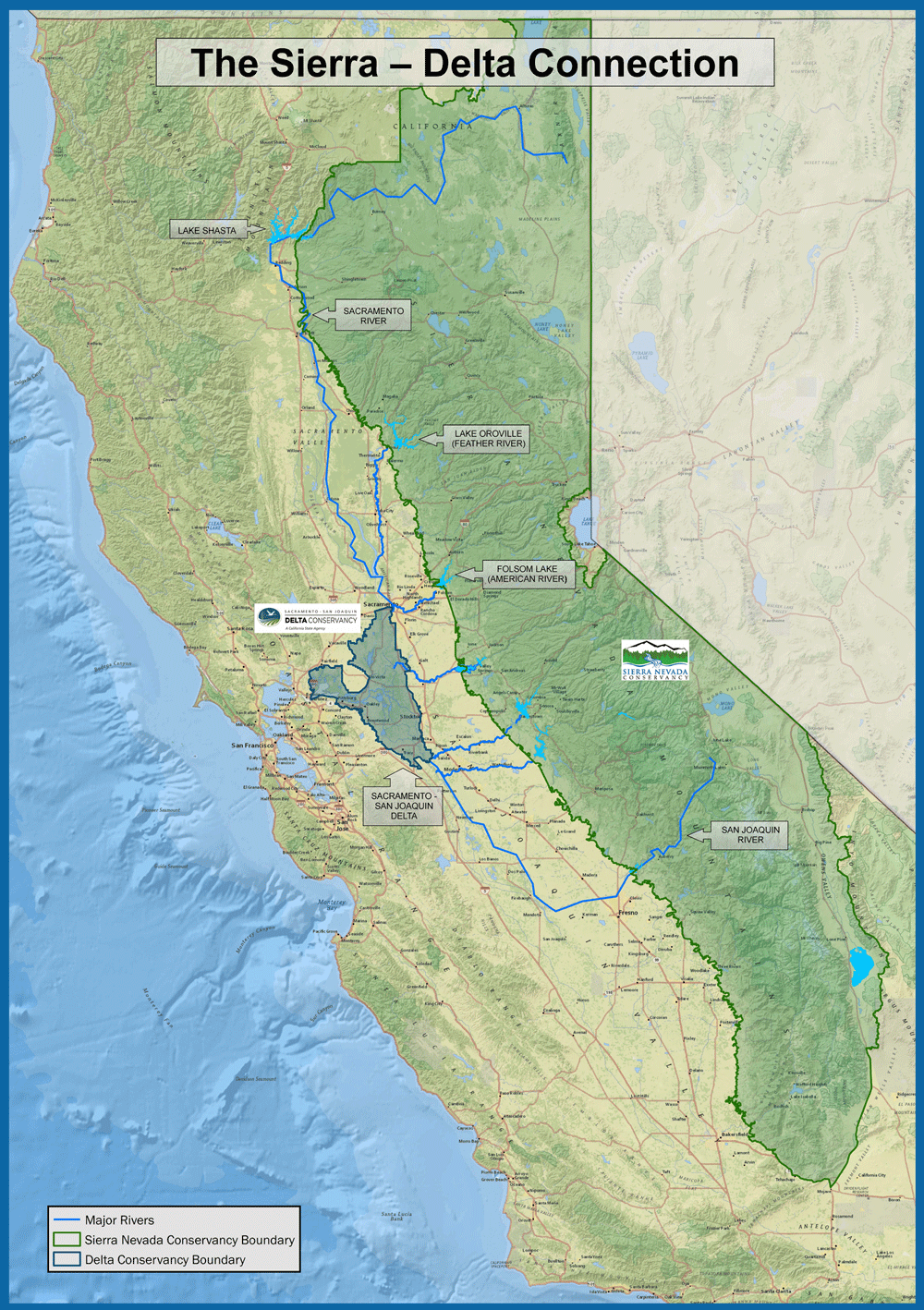

One arrives at an even more strikingly persuasive map, no doubt, by bleaching it of local toponym and topography alike, and foregrounding the web of water transport that reaches out of a thick central vein, and reaches most of the southern state that would ostensibly, in this perverse proposal, hive off as separate units, disconnected from the prime manmade surface aquifer which, albeit artificially, carries water to their residents across the very lines that the Draper-backed proposal mandates the law artificially sever, in ways that betray limited familiarity with the state’s water supplies, let alone the changes that climate change pose for the delicate balance that has historically that formed among the state’s diverse regions:
The historically built web of water supplied down the California Aqueduct and from the watershed that leads to Hetch Hetchy Reservoir to the rest of the state is artificial in nature, but a web that animates the ecosystems of the farmlands around where we live. Indeed, the web of freshwater that we have created links the state as an organism–with some 60% coming from the Sierra. After the break-up of the region into proto-states, perhaps we can dispense with the diversion of water to the Central California’s valley to San Diego and Orange County? In those regions, desalination plants could crowd the coastlines, at least in the short term increasing the number of local jobs if at massive cost to those new states.

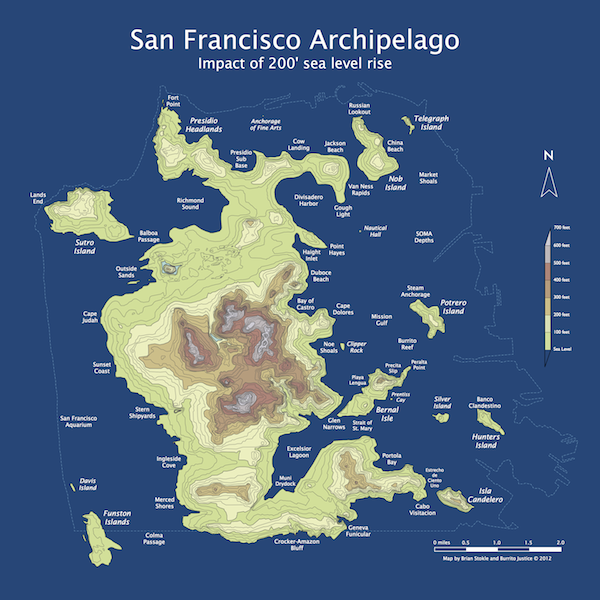
It’s a good way of forgetting the ways that we are bound to the allocation of resources, and to imagine that by going back to the drawing board with the idea that it can be a tabula rasa, we might be able to better sculpt the future out of the confused state of the present, and find clarification in letting us forget where we are by remapping out sense of the present lay of the land or our responsibility to it–rather than removing us from the land. And of the future of the state, evident in the selection of a new topographic map, from a futurist press release dated 2072, imagining the new shoreline created due to erosion and the disintegration of the arctic ice cap, created by Burrito Justice, of the remade San Francisco archipelago:
One might as well also think of the remapping of just a detail Los Angeles bay, from a more detailed map drawn by Spatialities that considered the shifts in toponymic place-names that will occur after a rise of water elevation of 260 feet:

As a consideration of the fragile supply of waters, the shifting of the known shoreline throws a wrench into the forward-looking rhetoric Draper uses.
Making maps that might attend more to natural resources, and less to administrative reorganization, would be a good place to start to think about our relation to the land. Francis Lieber was particularly concerned to develop administrative solutions that would lead to good government, reflecting his dedication to questions of political economy, and no doubt might stress administration of the land as an individual responsibility: Nullum jus sine officio, nullum officium sine jure (“No right without its duties, no duty without its rights”). Libertarians as Draper lose sight of this, and of what responsibilities might be lost in the proposed disaggregation of the state.


Excellent article..