
On 19 March 1813 the Rt Hon Sackville Hamilton, Chairman of the Directors General of Inland Navigation [DGIN], was examined by the House of Commons Committee on Inland Navigation in Ireland.[1] The focus was the disastrous affairs of the Royal Canal Company, but the River Inny was mentioned:
Is the river Inny navigable from Lough Derryvaragh to Lough Ree? — I apprehend not; but I understand that it is navigable from Ballynacarrow, through Lough Iron into Lough Derryvaragh, and from thence to Finea adjoining Lough Shillin; this navigation, however, is fit only for the country small boats, which, as I understand, are only from 7 to 10 tons burthen.
Would it be possible to render the river Inny navigable from Ballynacarrow to Lough Ree? — I apprehend it would; but that it would be more expensive than making a canal of the same extent.
What is the nearest point of Lough Ree, or any navigable part of the river Inny, to which such a canal ought to be brought? — I understand that a part of the river Inny, from Lough Ree to Shrule, or that neighbourhood, is now navigable; and it appears to me probable, that an engineer would recommend such a canal to be carried into the navigable part of the Inny near to Shrule, as being the nearest point by which such a navigation could join Lough Ree.
Has it ever been in the contemplation of the board to improve the navigation of the river Inny, from Lough Darryvaragh to the nearest point where it would come into the intended line [of the Royal Canal] from Coolnahay to Tarmonbarry? — It has not.
Asked whether he thought it would be a good idea to improve the Inny, Hamilton said that the DGIN had asked the Royal Canal Company to survey the ground between Coolnahay and the Inny, as an alternative to the planned route from Coolnahay to Tarmonbarry. The line was surveyed — he referred questions about details to the engineer John Killaly — and the Inny option was “found to be equally favourable in other respects”, being only half a mile from the Royal Canal near Ballynacarrow, but the Grand Canal Company objected vehemently to having the Royal come too near their canal.
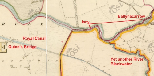
Lakes on the Inny (OSI 25″ ~1900)
In September 1810 the Royal Canal Company had advertised its interest in improving the Inny and in assessing the compensation it would have to pay to owners and occupiers of lands, and others affected, in counties Longford and Westmeath, along the line of the Inny between Ballymahon and Lough Shillin [Sheelin]. It thought it might have to make banks, cuts, trenches, water-courses, reservoirs and
… towing paths and ways for turning, hawling and drawing of boats, barges, lighters, and other vessels [and] wharfs, quays, store-houses, market-houses, locks, lock-houses, bridges, aqueducts, basons, or docks […].[2]
The navigability of the Inny
Nothing came of that remarkable piece of fantasy, but the proposal, and Hamilton’s comments, suggest that it might be interesting to check just how navigable the Inny was. Unfortunately neither Lewis’s Topographical Dictionary[3] of 1837 nor the Parliamentary Gazetteer[4] of 1846 has anything useful, although the Gazetteer does say of the Inny that
A proposal was long ago made to render the Inny navigable to Lough Derevaragh; and few rivers present, for such a length of way, so much facility for water-carriage.[5]
… the river Inny, which comes in from Westmeath, flows partly on the southern boundary, and partly within the southern border to the head of Lough Killymore, and offers peculiar though hitherto unappreciated facilities for inland navigation.[6]
A search of the British Newspaper Archive produced nothing useful between 1700 and 1850 apart from an interesting account of a ferry crossing. Small “country boats” on an unofficial navigation are unlikely to have troubled officialdom or to have greatly affected the flow of trade and, if they appear at all in the written record, are probably mentioned only in passing.
Accordingly, this account is based on an examination of the online Historic 6″ maps of the Ordnance Survey of Ireland, with occasional glances at later versions, supplemented by one nineteenth-century and some twentieth-century sources. I will be glad to hear from anyone who can add information from other sources: please leave a Comment below if you can help.
Note that this account works upstream, from Lough Ree to Lough Sheelin.
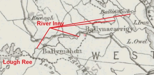
Lough Ree to Shrule
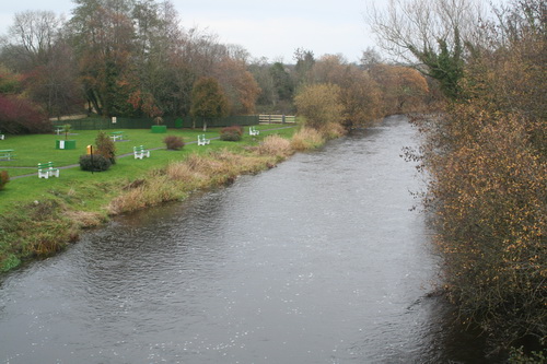
The section of the Inny most familiar to Irish inland boaters is probably the lowest part, from where the river joins Lough Ree [on the Shannon] to a bridge a little upstream: this section is [or was last time I was there] navigable even by fairly large vessels, with no obstacles other than a slight bar at the entrance to the river. [Folk intending to drive boats up there should check conditions for themselves before doing so.]
The Inny from Lough Ree to Ballinalack (OSI 25″ ~1900)
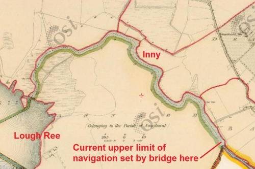
The Inny from Lough Ree to the current head of navigation (OSI 6″ ~1840)
A bridge is shown on the 25″ map, probably surveyed towards the end of the nineteenth century or in the first years of the twentieth: the OSI dates the survey between 1897 and 1913.
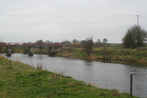
The red bridge
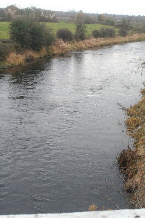
However, there was no such obstruction at the time of the 6″ survey (1829–1841) and there seems no reason to doubt that boats could have reached Shrule, where a corn mill and a flour mill could have provided cargoes.
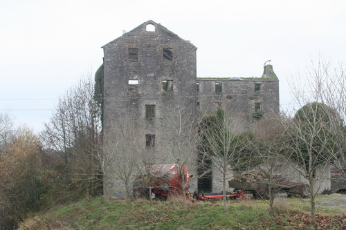
The flour mill at Shrulle
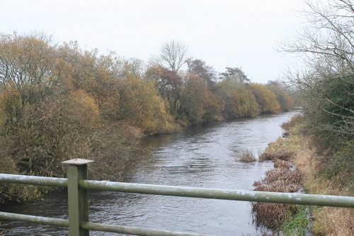
Looking downstream from Shrule bridge
And there is evidence to that effect. In 1807 the mills — then oil and corn mills — were offered to let, the ad stating “the river Inny being navigable to the Shannon, which is but one mile distant from the Mills”.[7]
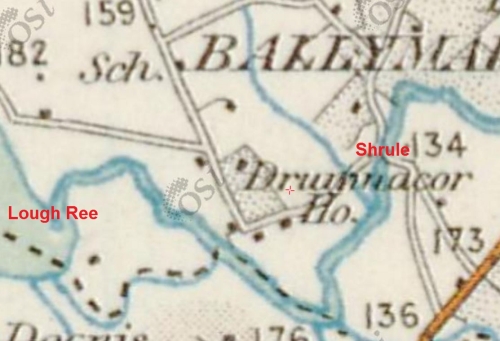
Lough Ree to Shrule (OSI 25″ ~1840)
Shrule to Ballynacarrow
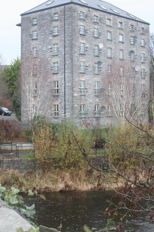
Former mill building in Ballymahon
Looking upstream from Ballymahon bridge
I found no evidence to suggest that the section of the Inny upstream of Shrule, through Ballymahon, was regarded as being navigable. A modern source suggests that it still isn’t, in the conventional sense: the Irish WhiteWater Guide, for canoeists and kayakists, says that the river has “many small rapids” between Newcastle Bridge, upstream of Ballymahon, and Shrule.
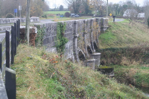
The Whitworth aqueduct carries the Royal Canal over the Inny near Abbeyshrule
Let us therefore skip rapidly upstream to Ballynacarrow.
Ballynacarrow (OSI 6″ ~1840)
Ballynacarrow to Lough Iron
Looking downstream from Ballynacarrow bridge [what is the large building on the left?]
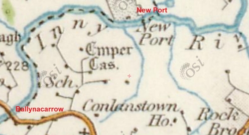
Ballynacarrow to New Port (OSI 25″ ~1900)
Unfortunately New Port itself shows no signs of docks, quays, wharfs, piers or other shipping infrastructure: nothing but obstructions in the form of two fords and an eel weir. Did some landowner dream of making his estate a major transport hub (as folk nowadays say)?
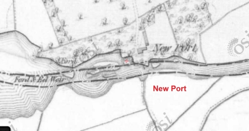
New Port (OSI 6″ B&W ~1840)
There were fords and eel weirs in several places along the Inny; the extract below shows a remarkable concentration of the things. Perhaps the country boats were of shallow enough draft to get over them.
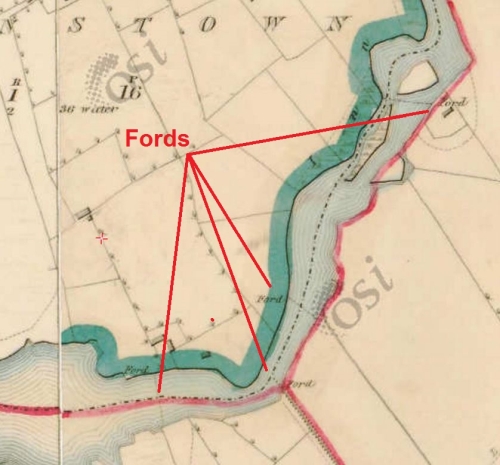
Fords (OSI 6″ ~1840)
On to the multi-piered Ballycorkey Bridge, which had an eel weir nearby. It also had a boat house: something I associate with the pleasure craft of the leisured classes rather than the working boats of the lower orders. I don’t, though, see a Big House anywhere nearby.
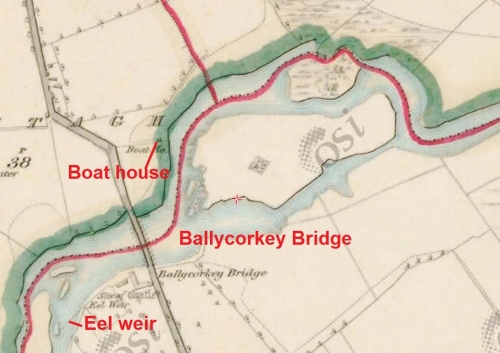
Ballycorkey (OSI 6″ ~1840)
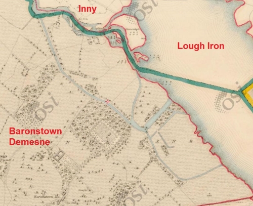
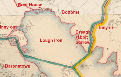
Lough Iron
According to Lewis, Lough Iron is
… the most western lake in the county [of Westmeath], and is likewise a long sheet of water, being a mile long and but ¼ of a mile broad, and very shallow: its banks are enriched with some fine scenery towards Baronstown and Kilbixy ….[8]
The Baronstown Demesne is at the point where the Inny leaves the lake [recall that we are travelling upstream] . The Parliamentary Gazetteer says of it
BARONSTOWN, a demesne on the west side of Lough Iron, barony of Moygoish, about 8 miles north-west of Mullingar, co Westmeath, Leinster. The mansion is a spacious Grecian structure, built chiefly by the late Lord Sunderlin, and now the seat of Mrs O’Connor. The demesne was enlarged by Lord Sunderlin, and enriched with extensive plantations. It derived its name from its ancient proprietors, the family of Nangle, palatine-barons of Navan; and it passed by purchase into the possession of the family of Malone.[9]
The Baronstown demesne (OSI 6″ ~1840)
But what is that? Why, it’s a canal! It is even so labelled on the map. In fact there seems to be quite a network of (admittedly small) bodies of water within the demesne, as well as a boathouse.
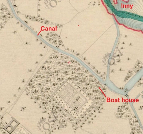
The Baronstown canal (OSI 6″ ~1840)
The canal was not necessarily for navigation: it might have been for irrigation or decoration — or for some combination of the three. It might have been built to bypass shallows at the Inny’s exit from Lough Iron.
I gather from the Buildings of Ireland website that Baronstown is no more. However, the OSI’s Ortho views suggest that the line of the canal is still discernible and I would be glad to hear from anyone who has seen it.
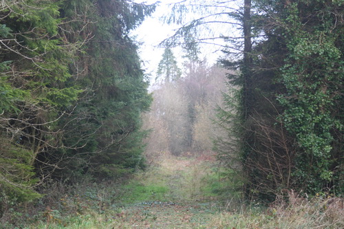
In Baronstown demesne: almost impassable once off the trackway
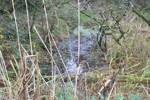
This could be anything (or the remains of anything). Finding the canal would need more time and heavy equipment
Lough Iron (OSI 6″ ~1840)
Lough Iron to Lough Derryvaragh
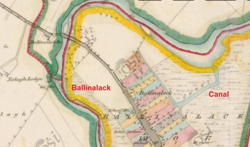
Ballinalack (OSI 6″ ~1840)
In 1939 Edward O’Regan and a friend set out on the Royal Canal, dfrom Blanchardstown, in a folding kayak. They left the canal for Lough Owel and hoped to follow a watercourse thence to Lough Iron. However, the water level was too low even for their boat, so they got a lift to the Inny upstream of Lough Iron and relaunched there.[10]
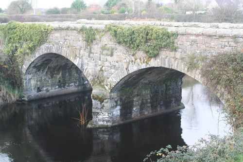
The old bridge at Ballinalack
As far as I can see, the most convenient place for the relaunch (because the road crosses the river) would have been at Ballinalack. And lo! It too has a canal.
What it’s doing there I cannot imagine, and the Wikipedia entry doesn’t help. Again, I would welcome information.
O’Regan described the Inny as “a brown, quiet river, as befitted one that lived mostly in a bog”. For two days they saw few signs of life. Like us, O’Regan and his companion were travelling upstream, against the current, but reported no difficulty in doing so; where the river widened below Lough Derravaragh the flow was negligible.[11] Perhaps conditions were equally suitable for navigation in the early nineteenth century.
Neither the map nor O’Regan’s account suggests any obstacle to navigation en route to, or on, Lough Derryvaragh. The 6″ OSI map shows a bathing house and what looks like a pier at Coolure on the north shore, a small quay on the east, another at Donore on the south and several boat-houses scattered hither and yon. The 25″ OSI map (below) shows a quay on the west side between what O’Regan called the influx and the efflux. O’Regan met an eel boat and
… a kind of barge affair that drew timber from one end of the lake to a sawmill at the other end. […] it made a monstrous noise with its ungainly outboard motor and chugged back and forth throughout the day ….[12]
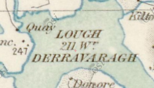
Quay on Lough Derryvaragh (OSI 25″ ~1900)
In more recent times a large turf-boat was extracted from Lough Derravaragh and given to the Folklife section of the National Museum[13] which, when I last enquired, said it was hidden in Daingean and could not be viewed.
Lough Derryvaragh to Lough Sheelin
O’Regan and his companion stopped at Float Bridge to go shopping in Coole. Called Wooden Bridge on the 6″ OSI map, this might be the location of the ferry accident referred to here.
Further upstream, Camagh Bridge has a quarry nearby: one of the few possible sources of cargo (other than turf) along the river.
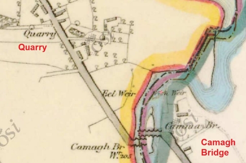
Camagh Bridge (OSI 6″ ~1840)
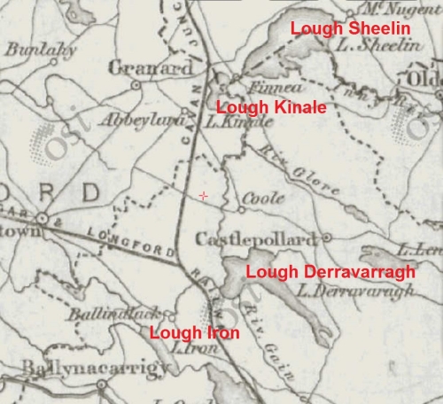
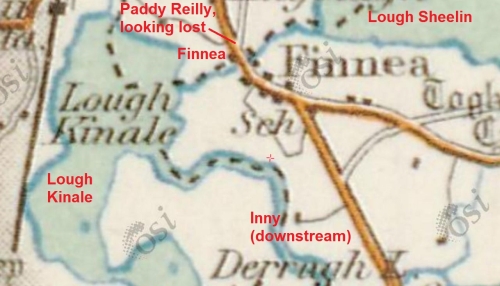
The river then reaches Lough Kinale and, after another short river stretch through Finnea, reaches Lough Sheelin.
Lough Kinale and Lough Sheelin (OSI 25″ ~1900)
The OSI 6″ map showed a new quay on Lough Kinale.
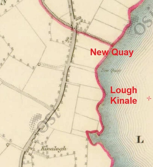
New Quay on Lough Kinale (OSI 6″ ~1840)
O’Regan found no sign of life on Lough Sheelin (no boats and nobody on shore) but the OSI 6″ map shows several boat-houses, as well as a dock at Summerville.
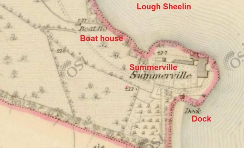
The dock at Summerville on Lough Sheelin (OSI 6″ ~1840)
Erskine Nicol
There is one other source of evidence that might be considered. The Scottish artist Erskine Nicol spent five years in Ireland, from 1845 to 1850, and later in life used a studio at Clonava, at the western end of Lough Derryvaragh.
This page has images of many of his paintings (keep pressing “Load More”). It’s a bit confusing because some appear more than once, with different titles. Just in case, here are direct links to some of them:
Turf cot returning from the bog [note the similarity to this]
The turf barge on the Royal Canal [rather small, surely?] aka Figures at work in a river landscape
Drainage works (added 20170515)
Many Irish rivers had drainage works carried out in the second half of the nineteenth century by the Board of [Public] Works. As a result, it may be unwise to base deductions about their pre-1850 navigability on their modern appearance. In the case of the Inny, we do at least have O’Regan’s twentieth-century evidence, but it might be interesting to see what drainage works were carried out.
Drainage works on the Upper Inny began some time after 2 February 1867, when the report of the Inspector, Samuel Roberts, to the Secretary of the Board of Works was published in the Longford Journal.[14] Drainage works required the setting up of a drainage district and other complications, apart from the engineering works themselves, and the Upper Inny works were not completed until some time in the year ending 31 March 1881.[15] The Inspector’s report details what he proposed should be done; the Commissioners’ report of 1881 gives no details, so it cannot be assumed that the works completed matched those proposed, but checking would require a visit to the National Archives in Dublin, which is more work than I want to undertake just at this moment.
With that caveat, then, here is what Samuel Roberts proposed. He remarked, incidentally, on the “peculiar feature in this District” of a very small fall over the 18½ miles between Lough Sheelin and Lough Iron, with a difference in levels of less than 11 feet in summer and in winter.
Roberts proposed [inter alia] to
- remove shoals in the Inny at Ballinalack, Ballyharney, Islandford, Cammagh and Finnea and improve the channel elsewhere
- remove eel-weirs
- rebuild “the public bridges” at Ballinalack, Cammagh and Finnea
- build a regulating weir at the outlet from Lough Derryvaragh so that it could act as a reservoir for flood waters. O’Regan didn’t mention a weir and I see no sign of it on the 25″ OSI map (~1900) or on the OSI’s Ortho views, so perhaps it wasn’t built
- build a regulating weir at the outlet from Lough Sheelin. The 25″ map shows a weir in Finnea, below the bridge; the OSI Ortho views don’t show it
- add sluices to Baronstown regulating weir, downstream of Lough Iron. This weir is not on the 6″ OSI map but is on the 25″; O’Regan would not have seen it as he launched upstream of Lough Iron. Roberts referred to a shoal and other obstructions between the weir and Lough Iron: the canal would have bypassed such obstructions
- carry out various works on tributaries and drains
- build a quay for turf boats at Ballinalack. That may be the notch below the old [OSI 25″ ~1900] bridge, now probably somewhere beneath the new bridge.
Other evidence
I intend to use this heading to add any information that comes my way. The first item is a news report from February 1867: three men in a turf cot, travelling downstream, found the decomposing body of “a man of respectable appearance” just above Float [Wooden] Bridge.[16]
Envoi
I have found nothing to suggest that the Inny was not used for the sort of small-scale carrying that Sackville Hamilton spoke of, and a certain amount of evidence that it was so used. Obviously this is a long way from providing full certainty, or a full account of the navigation’s history, so I would be glad to hear from anyone who can add information.
Notes and sources
[1] First Report from the Committee on Inland Navigation, in Ireland Ordered, by The House of Commons, to be Printed 11 May 1813 [198]
[2] Dublin Evening Post 22 September 1810
[3] Samuel Lewis A Topographical Dictionary of Ireland, comprising the several counties, cities, boroughs, corporate, market, and post towns, parishes and villages, with historical and statistical descriptions; embellished with engravings of the arms of the cities, bishopricks, corporate towns, and boroughs; and of the seals of the several municipal corporations: with an Appendix describing the electoral boundaries of the several boroughs, as defined by the Act of the 2d & 3d of William IV S Lewis & Co, London 1837
[4] The Parliamentary Gazetteer of Ireland, adapted to the new poor-law, franchise, municipal and ecclesiastical arrangements, and compiled with a special reference to the lines of railroad and canal communication, as existing in 1844–45; illustrated by a series of maps, and other plates; and presenting the results, in detail, of the census of 1841, compared with that of 1831 A Fullarton and Co, Dublin, London and Edinburgh 1846
[5] Ibid under Inny (The)
[6] Ibid under Longford
[7] Dublin Evening Post 3 December 1807
[8] Lewis op cit under Westmeath
[9] Parliamentary Gazetteer op cit under Baronstown
[10] Edward O’Regan In Irish Waters Currach Press, Dublin 2005
[11] ibid
[12] ibid
[13] The Future of Maritime and Inland Waterways Collections Heritage Council, Kilkenny 2007
[14] Longford Journal 2 February 1867
[15] Forth-Ninth Annual Report from the Commissioners of Public Works in Ireland; with appendices, for the year 1880–81 HMSO Dublin 1881
[16] Saunders’s News-Letter 18 February 1867
![]()
[turf95]


Abbeyshrule aerodrome is nowadays the centre of general aviation in the Irish Midlands. It is probably unique in having its main road approach along the side of an aqueduct, i.e. that carrying the Royal Canal over the River Inny..
There have been some floatplane operations from the river adjacent to the aerodrome. See Malcolm Nason’s 2009 photo of a Piper Cub at https://www.flickr.com/photos/shanair/4039694078/
Gracious. Thank you for that. bjg
Thank you for sharing this wonderful article .
I have often wondered about the ‘canal’ at Baronstown.
Check out the Maps on ..
http://dcenr.maps.arcgis.com/apps/MapSeries/index.html?appid=a30af518e87a4c0ab2fbde2aaac3c228
Or..
http://map.geohive.ie/
http://map.geohive.ie/mapviewer.html?webmap=9e236d3abc144d3991824808f8a13146
The Images are mush better that the OSI ORTHO Imagery .
Kind Regards,
Peter
Thank you, especially for the map links. bjg
Hello, a fine article and piece of resesrch. Can i ask, as a walker, do any sections of the Inny have a walkibg track like the Barrow? As oposed to tarmac. I would be intetested in exploring a lengthy section.
Thanks. The track along the Barrow was build as a towing-path or trackway to facilitate horses towing boats; see also the Suir (Clonmel to Carrick) and the Boyne. The Inny was never an “official” navigation with an act of parliament, and I presume that is why it never got a towing-path. It may be kayakable in parts, but there is no provision for walking as far as I know, although if anyone from the area, with local knowledge, can advise on this, I would be glad to hear from them. bjg
I fished the Inny regularly around Ballycorkery bridge and the canal section above the bridge still exists. The bridge over the canal is still there. Looks bizarre now surrounded by forest.
Always wondered about its history. Great article.